
Photo Record
Images
Metadata
Title |
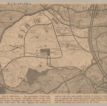
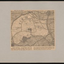
Greater Haverhill Space Center Task Force map of proposed NASA site, Haverhill, 1963 |
Object Type |
Print, Photomechanical |
Description |
Greater Haverhill Space Center Task Force map of proposed NASA site, Haverhill, 1963. The map shows an area with rough boundaries west of Route 495, north of Broadway, east of Sawyer Avenue, almost south of railroad tracks. Printed caption below: "Space Proposal - The preliminary NASA site, proposed by the Greater Haverhill Space Center Task Force, between Broadway and Hilldale Avenue, will cover nearly 3,500 acres. The plan suggests the network of roads in the site, and possible location of industry necessary to support the electronics research laboratories. The boundaries are not clearly defined to enable NASA to decide on the actual area necessary for the center." Newsclipping, published in the Haverhill Journal August 29, 1963. Print is 17 x 19 cm mounted on cardboard 26 x 33 cm. Housed with Historical Photographic Print Collection. |
Photographer |
Haverhill Journal |
Date |
1963 |
Processing Method |
Halftone photomechanical print |
Print size |
17 x 19 cm |
Call Number |
HK1.4 Senter HPH 56-784F |
Catalog Number |
31479006607906 |
Subjects |
Haverhill (Mass.) Maps Electronics--Research Aerospace industries |
Place |
Haverhill, MA |
People |
United States. National Aeronautics and Space Administration |
Search Terms |
Haverhill NASA National Aeronautics and Space Administration Maps Proposals Electronics Business Greater Haverhill Space Center Task Force Greater Haverhill Space Center Haverhill Journal |
Collection |
Haverhill History Collection |
Provenance |
Found in collection. |
Digital Collection |
Senter Digital Archive |
Copyright Statement |
Copyright is not held by the Haverhill Public Library. The library retains custodial rights. |
Related Records |
Show Related Records... |
Last Updated |
2022-03-03 |