Search Term Record
Metadata
Search Term |
Proposals |
Number of Object records |
0 |
Number of Photo records |
20 |
Number of Archive records |
0 |
Number of Library records |
0 |
Related Records
-
Aerial view, proposed site of electron volt accelerator, Haverhill, 1966 - Print, Photographic
Aerial view, proposed site of an electron volt accelerator, Haverhill, 1966. Route of proposed accelerator marked in dark blue pen. The 1966 Journal of the Senate of the United States of America, Second Session of the Eighty-Ninth Congress, January 14, noted "A resolution favoring the selection of the city of Haverhill, Mass., as the location for the Atomic Energy Commission's proposed 200 billion electron volt accelerator; to the Joint Commissio...
Record Type: Photo
-
Commercial Housing Project, proposal, White's Corner, Haverhill, 1972 - Print, Photographic
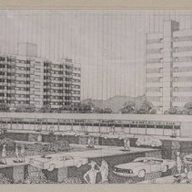
Commercial Housing Project, proposal, White's Corner, Haverhill, 1972. Photograph of a monochrome drawing, proposed pair of apartment towers, ten stories. The DeMoulas shopping plaza (Central Plaza) is in the foreground, with cars and pedestrians; foliage in the foreground, hills in the distance. The drawing is not signed but this is a photograph of the drawing, could be cropped. Inscription on verso: "White's Corner / Proposed Plan: / $5 million...
Record Type: Photo
-
G.A.R. Park, proposed new bandstand, Haverhill, 1972 - Print, Photographic
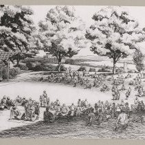
G.A.R. Park, proposed new bandstand or bandshell, Haverhill, 1972. Black and white photograph of an architectural rendering, showing a bandstand on the left, open sides with slanted trapezoidal roof on posts. A band is shown on the bandstand, with a crowd of people, some on picnic blankets on the grass, some walking. Trees in the background. The image probably appeared in the Haverhill Gazette. Printed caption mounted below: "Expanded GAR Park, t...
Record Type: Photo
-
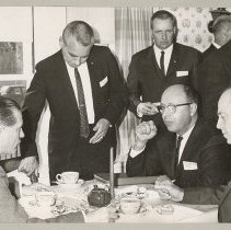
Governor Volpe, Mayor Chase, electron volt accelerator meeting, Haverhill, 1966 - Print, Photographic
Massachusetts Governor John A. Volpe, Mayor Paul I. Chase, electron volt accelerator meeting, Haverhill, 1966. Eight men are in a room, location not identified; three are seated at a table which has a tea pot and cups of tea, the man seated in the middle with his elbow on a bound report. The other men are not identified; they have cards in their suit breast pockets with their names or affiliations written on them, the only other card legible besi...
Record Type: Photo
-
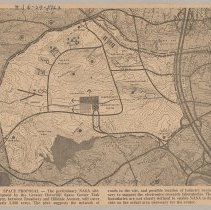
Greater Haverhill Space Center Task Force map of proposed NASA site, Haverhill, 1963 - Print, Photomechanical
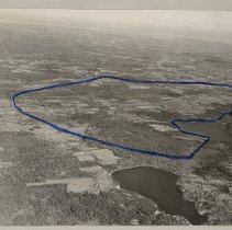
Greater Haverhill Space Center Task Force map of proposed NASA site, Haverhill, 1963. The map shows an area with rough boundaries west of Route 495, north of Broadway, east of Sawyer Avenue, almost south of railroad tracks. Printed caption below: "Space Proposal - The preliminary NASA site, proposed by the Greater Haverhill Space Center Task Force, between Broadway and Hilldale Avenue, will cover nearly 3,500 acres. The plan suggests the network ...
Record Type: Photo
-
Haverhill Municipal Hospital [Hale Hospital], architect's drawing by Clinton Foster Goodwin - Print, Photographic
Haverhill Municipal Hospital [Hale Hospital], architectural rendering by Clinton Foster Goodwin. Inscription on verso of insert: "Architects elevation view of Hale Hospital Addition 195 / Designed by Clinton F. Goodwin." Photograph of architect's black and white rendering, showing the front of the four and three story building. A tall flagpole with an American flag is in front of the hospital. Caption: "Haverhill Municipal Hospital," and in the b...
Record Type: Photo
![Haverhill Municipal [Hale] Hospital, drawing by Clinton Foster Goodwin](https://s3.amazonaws.com/pastperfectonline/images/museum_133/035/thumbs/31479006489248.jpg)
-
Haverhill Public Library, proposed additions rendering, Main Street, Haverhill - Photocopy
Haverhill Public Library, proposed additions rendering, Main Street, Haverhill. Color photocopy / electrophotography print of a photograph with proposed new library additions rendered on top of existing library. Includes brick bell tower on Main Street, third floor, addition on the right with two and one stories. G.A.R. Park in the foreground, City Hall on Summer Street on the left. Undated; the library did not choose this design and the approved...
Record Type: Photo
-
Haverhill Public Library, proposed additions rendering, Summer Street, Haverhill - Photocopy
Haverhill Public Library, proposed additions rendering, view from Summer Street, Haverhill. Color photocopy / electrophotography print of a photograph with proposed new library additions rendered on top of existing library. Includes brick bell tower on Main Street, on the right, third floor, auditorium addition on the left. Main Street and Haverhill Bridge, Bradford on the right and in the background. Undated; the library did not choose this desi...
Record Type: Photo
-
Map of Haverhill, proposed County Bridge across the Merrimack River - Print, Photographic
Map of Haverhill, proposed County Bridge across the Merrimack River. Photograph of a map showing Bradford on the left, Merrimack River in center showing existing Railroad Bridge and "Proposed Highway Bridge" parallel to it, Haverhill with River Street on the right. The County Bridge was built in 1906. This is a later photo. See HK1.4 Senter HPH 56-786A.
Record Type: Photo
-
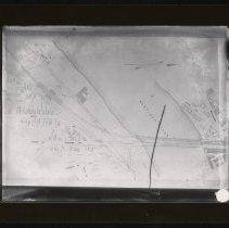
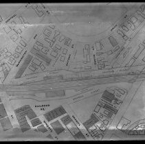
Map of Haverhill, proposed streets near Haverhill Station - Negative, Glass Plate
Map of Haverhill, proposed streets near Haverhill Station. Railroad tracks running horizontally across the center, Railroad Square below, Washington Avenue above, Essex Street on the right. Two streets labeled "Proposed Street" above and below the tracks. Map is untitled and undated, probably early 20th century, photograph probably the same time period. Label on glass: "212 F."
Record Type: Photo
-
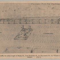
Parking lot, proposal, Emerson Street, Haverhill, 1963 - Print, Photomechanical
Parking lot, proposal, Emerson Street, Haverhill. Architectural rendering/plan, bird's-eye view of rectangular parking lot with long side at Merrimack Street at top, rectangular center island with tree, Emerson Street on the right. Printed caption: "Proposed parking lot, the entire length of Bailey St., from Emerson St., to Merrimack St., by William A. Conte, real estate developer." Ink annotation: "1963." Clipping is 14 x 23 cm mounted on cardbo...
Record Type: Photo
-
Plan of unknown city square with obelisk - Transparency, Lantern Slide
Illustration, plan of unknown city square with obelisk in the center. Five buildings on the square, the largest building taking up one side of the plaza, with a large clock tower at the center. Other buildings surrounding the square. Streetcars, pedestrians and a few vehicles are illustrated. The slide's mat and label indicate it is from John H. Thurston of Boston; on reverse label is written in pencil "St Louis?" From a series of lantern slides,...
Record Type: Photo
-
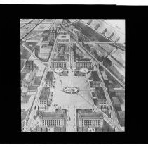
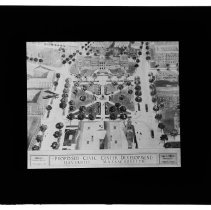
Proposed Civic Center illustration, architect Charles D. White, Haverhill, 1919 - Transparency, Lantern Slide
Proposed Civic Center illustration, architect Charles D. White, Haverhill, 1919. Illustration shows City Hall Park (later G.A.R. Park), with Hannah Duston Statue; Pentucket Club, formerly known as the Moses B. Moody House; Haverhill High School; City Hall; streetcars; pedestrians; and a biplane flying overhead on the left. Caption: "Haverhill Planning Board / December 1919 / Proposed Civic Center Development / Haverhill, Massachusetts / Charles D...
Record Type: Photo
-
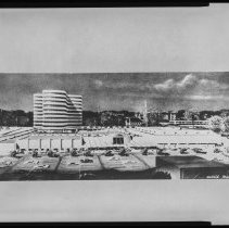
Proposed high rise building and complex, Haverhill, 1965 - Negative, Sheet Film
Architectural rendering of a proposed high rise building and surrounding complex, Haverhill, circa 1965. Signed "Wallace Young" at bottom right of image. Inscription with print in file: "Proposal for redevelopment of Merrimack Street at Main Street after Urban Renewal."
Record Type: Photo
-
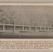
Shopping center, proposal, White's Corner, Haverhill - Print, Photomechanical
Shopping center, proposal, White's Corner, Haverhill. One level building, view of front and right sides, large "Sargent" sign on the front at the top. Car on the right. Photomechanical print. Printed caption: "Shopping Center planned for White's Corner under urban renewal is shown in this artist's sketch. Developer of the complex will be T. A. DeMoulas, who is negotiating with the Haverhill Housing Authority. The proposal calls for a 60,000 squar...
Record Type: Photo
-
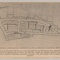
Urban Renewal Phase One, plan of area to be developed downtown, Haverhill, 1963 - Print, Photomechanical
Overhead street plan, downtown Haverhill. Caption at top left: "Illustrative Site Plan." Printed caption below: "First Phase of urban renewal in Haverhill will be on an area bounded by the Merrimack River, Main St. and a new street (Relocated Route 97) between GAR Park and the intersection of Water and Mill Streets. Within six months, the City Council will be asked to approve Phase 1 for redevelopment, after a series of meetings and public hearin...
Record Type: Photo
-
Winnekenni Park, aerial view of proposed veterans' memorial area, Haverhill, 1962 - Print, Photomechanical
Winnekenni Park and Winnekenni Castle, aerial view of proposed veterans' memorial area, Haverhill, 1962. Two small outbuildings with gable roofs are on the left, with Winnekenni Castle in the center another two story building on the left. Trees surrounding the buildings. Photomechanical print of a photograph. Printed caption below: "Proposed Living Memorial - Aerial photograph of Winnekenni castle and surrounding grounds shows part of the park ar...
Record Type: Photo
-
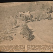
Winnekenni Park, aerial view of proposed veterans' memorial area, Haverhill, 1962 - Print, Photomechanical
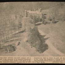
Winnekenni Park and Winnekenni Castle, aerial view of proposed veterans' memorial area, Haverhill, 1962. Two small outbuildings with gable roofs are on the left, with Winnekenni Castle in the center another two story building on the left. Trees surrounding the buildings. Photomechanical print of a photograph. Printed caption below: "Recreation Center - Haverhill residents will at last be able to take advantage of the beautiful Winnekenni Park as ...
Record Type: Photo