Related Records
-
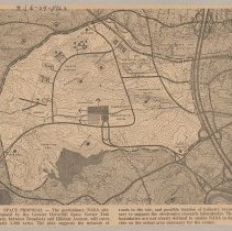
Greater Haverhill Space Center Task Force map of proposed NASA site, Haverhill, 1963 - Print, Photomechanical
Greater Haverhill Space Center Task Force map of proposed NASA site, Haverhill, 1963. The map shows an area with rough boundaries west of Route 495, north of Broadway, east of Sawyer Avenue, almost south of railroad tracks. Printed caption below: "Space Proposal - The preliminary NASA site, proposed by the Greater Haverhill Space Center Task Force, between Broadway and Hilldale Avenue, will cover nearly 3,500 acres. The plan suggests the network ...
Record Type: Photo