Search Term Record
Metadata
Search Term |
Maps |
Number of Object records |
0 |
Number of Photo records |
67 |
Number of Archive records |
0 |
Number of Library records |
0 |
Related Records
-
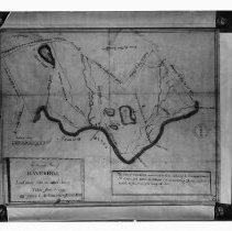
Accurate Plan of Haverhill Laid down from an actual Survey Taken June 1st 1795 - Negative, Glass Plate
Map of Haverhill, 1795. Title: "An Accurate Plan of Haverhill Laid down from an actual Survey Taken June 1st 1795 by James C. McFarland & Josiah Noyes." Shows roads, rivers, ponds, bridges, ferries and mills. With scale of rods to miles. Mass. Archives inkstamp on the right. Black and white negative. See article by Mabel D. Mason, HK1.2 Senter HPH 56-784A.
Record Type: Photo
-
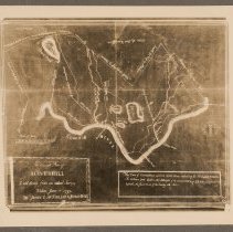
Accurate Plan of Haverhill Laid down from an actual Survey Taken June 1st 1795 - Print, Photographic
Map of Haverhill, 1795. Title: "An Accurate Plan of Haverhill Laid down from an actual Survey Taken June 1st 1795 by James C. McFarland & Josiah Noyes." Shows roads, rivers, ponds, bridges, ferries and mills. With scale of rods to miles. Photograph of a photostat, probably the copy held by the Haverhill Historical Society. See glass negative HK1.2 Senter G5x7 7-29. Photo is 13 x 15 cm mounted on cardboard 26 x 36 cm.
Record Type: Photo
-
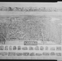
Aero view of Haverhill Massachusetts 1914 - Negative, Sheet Film
Map: "Aero view of Haverhill Massachusetts 1914." Does not include Bradford, bottom of map is Merrimack River. Top and bottom feature images of city and manufacturing buildings with captions, with a list of other businesses at bottom. The map is drawn as an aerial view with 3-D renderings of buildings, houses, trees, bridges; larger streets are named. Lower right corner beneath image: "Drawn by Fowler & Downs."
Record Type: Photo
-
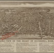
Aero-view of the Heart of Haverhill, Mass. - Print, Photomechanical
Bird's-eye view map of Haverhill, photomechanical print, promotional publication for the Haverhill National Bank. Title: "Aero-view of the Heart of Haverhill, Mass." Probably early 20th century, the new High School on Summer Street is visible. The map is printed in brown with a red arrow and the words "New Building of / Haverhill National Bank" in Washington Square. Lake Pentucket is in the upper right, the Railroad Bridge and County Bridge acros...
Record Type: Photo
-
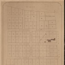
A. M. Tilton's land adjacent to Main Street, plan of lots, Haverhill, 1897 - Print, Photographic
A. M. Tilton's land adjacent to Main Street, plan of lots, Haverhill, 1897. Title at bottom: "Plan of Land / of / A. M. Tilton / Main Street Haverhill, Mass. / known as / Wayside Farm / offered for sale in lots to suit purchasers / Inquire of A. M. Tilton 93-95 Merrimack Street, Haverhill / Scale: 50 feet to 1 inch / Roger Tappan, Surveyor / July, 1897." Named adjacent plots belong to Mrs. Clara Harris, C. N. Hoyt, and Mrs. Betsey Bartlett. North...
Record Type: Photo
-
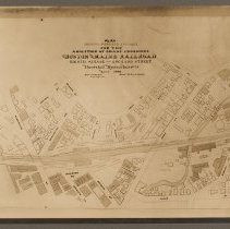
Boston & Maine Railroad, plan of abolition of grade crossings, Haverhill, 1900 - Print, Photographic
Boston & Maine Railroad, plan of abolition of grade crossings, Haverhill, 1900. The tracks are shown crossing Washington Street and Essex Street. Map title: "Plan / showing proposed changes / for the / abolition of grade crossing / Boston and Maine Railroad / Eighth Avenue - Orchard Street / Haverhill Massachusetts / March 1900 / Robert R. Evans / City Engineer / Scale 46 feet - 1 inch." Photo faded. Photo is 16 x 21 cm mounted on cardboard 28 x ...
Record Type: Photo
-
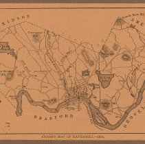
Chase's Map of Haverhill, 1861, from 250th Anniversary of Haverhill by Watkins, 1890 - Print
Map of Haverhill showing the Merrimack River and borders with Bradford, Methuen, Salem (NH), Atkinson (NH), Plaistow (NH), Amesbury, West Newbury and Groveland. Printed caption at bottom: "Chase's Map of Haverhill - 1861." Pasted to verso is the source, "250th Anniversary of ye Anciente Towne of Haverhill, 1890," series 1640. Quaint Chronicles. 1890 by Walter K[endall] Watkins, published by F. S. Blanchard & Company of Worcester, Mass. Printed in...
Record Type: Photo
-
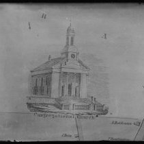
Congregational Church, Haverhill, illustration - Negative, Glass Plate
Illustration of the Congregational Church, Haverhill. From an inset in a map, some streets and houses below. Map date 1851: "Map of the Town of Haverhill Essex County, Mass." by Henry F. Walling, published by A. B. Jaques.
Record Type: Photo
-
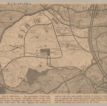
Greater Haverhill Space Center Task Force map of proposed NASA site, Haverhill, 1963 - Print, Photomechanical
Greater Haverhill Space Center Task Force map of proposed NASA site, Haverhill, 1963. The map shows an area with rough boundaries west of Route 495, north of Broadway, east of Sawyer Avenue, almost south of railroad tracks. Printed caption below: "Space Proposal - The preliminary NASA site, proposed by the Greater Haverhill Space Center Task Force, between Broadway and Hilldale Avenue, will cover nearly 3,500 acres. The plan suggests the network ...
Record Type: Photo
-
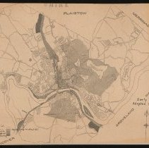
Haverhill and Bradford map, zoning districts, 1925 - Print, Photomechanical
Haverhill and Bradford map, zoning districts, 1925. Cropped, title at left cut off, "[Hav]erhill [Massachu]setts [Ci]ty Engineer." Ink annotation provides the legend titles, which include General Residential, Restricted Residential, Business, Industrial, and Unrestricted. Ink annotation on the right: "Early Zoning / Adopted Oct. 1925." The borders with other towns labeled are Plaistow (N.H.), Merrimac, West Newbury, Groveland, Methuen. Print is 2...
Record Type: Photo
-
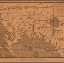
Hubbard's Map of New England, 1677, reproduction, showing Haverhill and Bradford - Print
William Hubbard's Map of New England, 1677, reproduction, showing Haverhill and Bradford among other cities in what would later be Massachusetts, Rhode Island, Connecticut, New Hampshire, Maine. The map is oriented with North as toward the right. Printed caption at bottom: "Hubbard's Map of New England. - 1677. / The first Engraved Map showing the location of Haverhill." Appeared in William Hubbard's "The Present State of New-England," map may ha...
Record Type: Photo
-
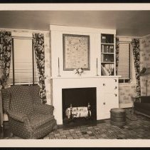
Le Baron-Bonney Company, interior, South Main Street, Bradford, Haverhill, ca. 1940 - Print, Photographic
Le Baron-Bonney Company, interior, 222 South Main Street, Bradford, Haverhill. Fireplace with built in cupboards or ovens and shelves on the right, windows on the left and right, upholstered chair and table on the left, sofa on the right. Toile wallpaper. Birch logs in the andirons and a wooden bucket on the right of the fireplace. Framed map over the mantel in the Le Baron - Bonney illustrative style, of the "Eastern Way" and the Gulf of Maine....
Record Type: Photo
-
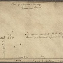
Leonard Cemetery map, Samuel Leonardson's grave, Griswold, Conn., 1909 - Print, Photographic
Leonard Cemetery map, Samuel Leonardson's grave, Griswold, Conn., original circa 1909. Typed label on verso: "Preston, Connecticut, Oct. 15, 1909. We visited the Leonard cemetery in the town of Griswold (formally the North Society of Preston), and made a plan of the cemetery, showing the grave of Samuel Leonard. The stone marked A is the grave you are in search of, and it is made of marble, a small stone, B&C on larger marble stones, most of the ...
Record Type: Photo
-
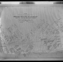
Map, Boston & Maine Railroad, Eighth Ave. to Orchard Street, Haverhill, 1900 - Negative, Glass Plate
Boston & Maine Railroad map, Haverhill, 1900. Full title: "Plan showing existing conditions in the vicinity of the Boston and Maine Railroad from Eighth Avenue to Orchard Street within the city of Haverhill, Massachusetts. March 1900." Railroad tracks, streets, buildings and properties. City Engineer: Robert R. Evans. Scale: 40 feet to 1 inch. Emulsion damaged, label on glass faded. Date of photograph early 20th century. See print HK1.8 Senter HP...
Record Type: Photo
-
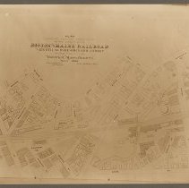
Map, Boston & Maine Railroad, Eighth Ave. to Orchard Street, Haverhill, 1900 - Print, Photographic
Boston & Maine Railroad map, Haverhill, 1900. Full title: "Plan showing existing conditions in the vicinity of the Boston and Maine Railroad from Eighth Avenue to Orchard Street within the city of Haverhill, Massachusetts. March 1900." Railroad tracks, streets, buildings and properties. City Engineer: Robert R. Evans. Scale: 40 feet to 1 inch. See glass negative HK1.8 Senter G6x8 14-16. Photo is 15 x 21 cm mounted on cardboard 27 x 31 cm.
Record Type: Photo
-
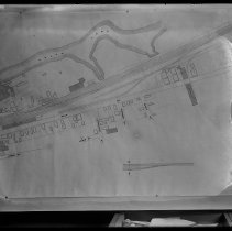
Map, Boston & Maine Railroad, Hale Street, Haverhill - Negative, Glass Plate
Map, Boston & Maine Railroad, Hale Street, Haverhill. Hale's Pond and Lafayette Square in the top half. Railroad tracks, streets, buildings and properties. Emulsion damaged. Map is untitled and undated, probably early 20th century, photograph probably the same time period. Label on glass: "213 F." See print HK1.8 Senter HPH 56-786D.
Record Type: Photo
-
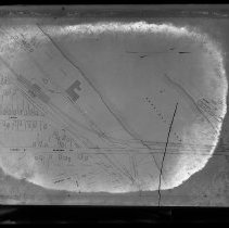
Map, Boston & Maine Railroad, proposed County Bridge, Haverhill - Negative, Glass Plate
Map, Boston & Maine Railroad, proposed County Bridge, Haverhill. Map shows the Merrimack River, Haverhill on the left, Bradford on the right. The existing Boston & Maine Railroad Bridge is shown with the proposed extension of Blossom Street and "Highway Bridge" below it. Railroad tracks, streets, bridges, buildings and properties. Label on glass: "214 F." Map is untitled and undated, probably circa 1903, when County Bridge was proposed; photograp...
Record Type: Photo
-
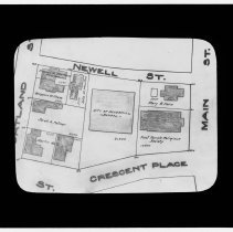
Map detail, Crescent Place and Haverhill High School - Transparency, Lantern Slide
Map detail, Crescent Place and Haverhill High School. First Parish Church, houses and property lines are shown. Bordering streets include Main Street, Newell Street, Portland Street. Names of property owners are Frances M. Sherburne, Julia M. Moulton, Mary B. Horn, Martin Kelly, Sarah A. Palmer, Benjamin W. Chase. Date and title of map not visible, but probably prior to new High School opening, 1909 / 1910.
Record Type: Photo
-
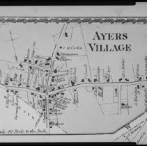
Map of Ayers Village, Haverhill, 1856 - Negative, Sheet Film
Map of Ayers Village, Haverhill; possibly an inset, more map content is cut off at the bottom edge. Inscription on housing: "Ayers Village 1856." Unnamed streets with property owner's names or function for each house, business or town building. Decorative border on top and left sides only. Scale "40 rods to the inch." Number "32" in top left corner; "W" in bottom right corner.
Record Type: Photo
-
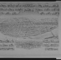
Map of Bradford, 1892, bird's-eye view - Negative, Sheet Film
Large bird's-eye view map of Bradford with named streets, 31 small insets with key town or industrial buildings, schools, churches. Ward Hill inset at bottom. Map title at bottom: "Bradford, Massachusetts, 1892." by O. H. Bailey & Co., lith. & pub. Boston. Original map had closed tear and some creasing but no loss. For detail of Ward Hill, see HK2 Senter F4x5 12-64.
Record Type: Photo