
Photo Record
Images
Metadata
Title |
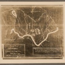
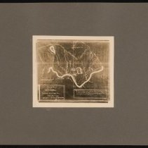
Accurate Plan of Haverhill Laid down from an actual Survey Taken June 1st 1795 |
Object Type |
Print, Photographic |
Description |
Map of Haverhill, 1795. Title: "An Accurate Plan of Haverhill Laid down from an actual Survey Taken June 1st 1795 by James C. McFarland & Josiah Noyes." Shows roads, rivers, ponds, bridges, ferries and mills. With scale of rods to miles. Photograph of a photostat, probably the copy held by the Haverhill Historical Society. See glass negative HK1.2 Senter G5x7 7-29. Photo is 13 x 15 cm mounted on cardboard 26 x 36 cm. |
Date |
n.d. |
Processing Method |
Gelatin silver print |
Print size |
13 x 15 cm |
Original/Copy |
Copy |
Call Number |
HK1.2 Senter HPH 56-784C |
Catalog Number |
31479006607872 |
Subjects |
Haverhill (Mass.) Maps Rivers Merrimack River (NH and Mass) |
Place |
Haverhill, MA |
People |
McFarland, James C. Noyes, Josiah |
Search Terms |
Haverhill Maps James C. McFarland McFarland Josiah Noyes Noyes Rivers Merrimack River |
Collection |
Haverhill History Collection |
Provenance |
Found in collection. |
Digital Collection |
Senter Digital Archive |
Copyright Statement |
Copyright is not held by the Haverhill Public Library. The library retains custodial rights. |
Related Records |
Show Related Records... |
Last Updated |
2022-03-01 |