
Photo Record
Images
Metadata
Title |
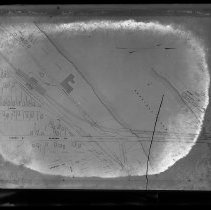
Map, Boston & Maine Railroad, proposed County Bridge, Haverhill |
Object Type |
Negative, Glass Plate |
Description |
Map, Boston & Maine Railroad, proposed County Bridge, Haverhill. Map shows the Merrimack River, Haverhill on the left, Bradford on the right. The existing Boston & Maine Railroad Bridge is shown with the proposed extension of Blossom Street and "Highway Bridge" below it. Railroad tracks, streets, bridges, buildings and properties. Label on glass: "214 F." Map is untitled and undated, probably circa 1903, when County Bridge was proposed; photograph probably close to the same time period. |
Date |
n.d. |
Processing Method |
Dry plate glass negative |
Film Size |
17 x 22 cm |
Call Number |
HK1.8 Senter G6x8 14-21 |
Catalog Number |
31479006447873 |
Subjects |
Haverhill (Mass.) Bradford (Haverhill, Mass.) Maps Bridges Railroad bridges Merrimack River (NH and Mass) Rivers |
Place |
Haverhill, MA |
People |
Boston and Maine Railroad |
Search Terms |
Haverhill Bradford Maps B & M Railroad Boston & Maine Railroad B & M Railroad Bridge Boston & Maine Railroad Bridge Railroads Bridges Railroad bridges Streets Blossom Street County Bridge Merrimack River Rivers Transportation |
Collection |
Haverhill History Collection |
Provenance |
Found in collection. |
Digital Collection |
Senter Digital Archive |
Copyright Statement |
Copyright is not held by the Haverhill Public Library. The library retains custodial rights. |
Related Records |
Show Related Records... |
Last Updated |
2018-09-07 |