Search Term Record
Metadata
Search Term |
Railroads |
Number of Object records |
0 |
Number of Photo records |
179 |
Number of Archive records |
0 |
Number of Library records |
0 |
Related Records
-
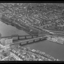
Aerial view of County Bridge and Railroad Bridge, Haverhill, 1929 - Print, Photographic
Aerial view of County Bridge and Railroad Bridge, Haverhill, 1929. Railroad Bridge (right) and County Bridge (left) crossing the Merrimack River with Bradford partly visible at bottom right. Inscription on verso: "Haverhill / Aeroplane view / 1929." See also HG9 Senter HPH 28-389B. Photo is 14 x 18 cm mounted on cardboard 26 x 36 cm.
Record Type: Photo
-
Aerial view of County Bridge and Railroad Bridge, Haverhill, 1929 - Print, Photographic
Aerial view of County Bridge and Railroad Bridge, Haverhill, 1929. Railroad Bridge (right) and County Bridge (left) crossing the Merrimack River with Bradford partly visible at bottom right. Inscription on verso: "Haverhill / Aeroplane view / 1929." See also HG9 Senter HPH 28-390C. Photo is 13 x 18 cm mounted on cardboard 20 x 24 cm.
Record Type: Photo
-
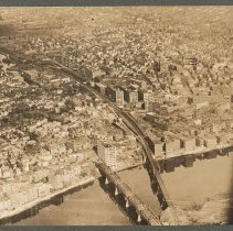
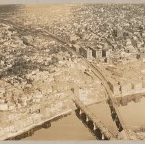
Aerial view of County Bridge and Railroad Bridge, looking north, Haverhill, 1929 - Negative, Glass Plate
Aerial view of County Bridge and Railroad Bridge, crossing the Merrimack River, looking north to Mount Washington, Silver Hill and Tilton School, Haverhill, 1929. Bradford visible at lower left. See HG9 Senter HPH 28-389E, 28-390E.
Record Type: Photo
-
Aerial view of County Bridge and Railroad Bridge, looking north, Haverhill, 1929 - Print, Photographic
Aerial view of County Bridge and Railroad Bridge, looking north to Mount Washington, Silver Hill and Tilton School, Haverhill, 1929. Inscription on verso: "Airplane view of Haverhill - 1929 / Railroad & County Bridges - Silver Hill in distance." See HG9 Senter G4x5 3-28, HG9 Senter HPH 28-389E. Photo is 14 x 18 cm mounted on cardboard 26 x 36 cm.
Record Type: Photo
-
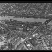
Aerial view of County Bridge and Railroad Bridge looking South to Bradford, Haverhill, 1929 - Negative, Glass Plate
Aerial view of Haverhill, County Bridge and Railroad Bridge looking south to Bradford. Probably 1929.
Record Type: Photo
-
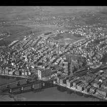
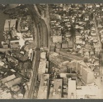
Aerial view of downtown shoe district looking South to Bradford, Haverhill, 1929 - Negative, Glass Plate
Aerial view of downtown shoe district looking south to Merrimack River and Bradford, Haverhill, 1929. County and railroad bridges on the right. Glass cracked.
Record Type: Photo
-
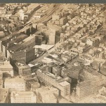
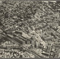
Aerial view of Essex, Walnut and Locust Streets, Haverhill, 1929 - Print, Photographic
Aerial view of Essex, Walnut and Locust Streets, looking north, Haverhill, 1929. Shoe district buildings, houses, churches. Railroad tracks on the left. Inscription on verso: "Airplane View of Haverhill - 1929 / Essex St. (left) - R.R." See glass negative HG9 Senter G4x5 3-9, print HG9 Senter HPH 29-391D. Photo is 14 x 18 cm mounted on cardboard 26 x 36 cm.
Record Type: Photo
-
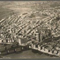
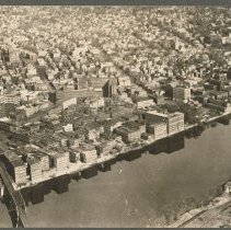
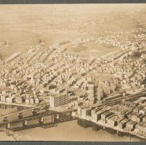
Aerial view of Haverhill, 1929 - Print, Photographic
Aerial view of Haverhill, 1929. Haverhill with Railroad Bridge on the left, small part of County bridge on the far left, Bradford at bottom right (south) across the Merrimack River. Part of airplane on the right. Inscription on verso: "Airplane view of Haverhill - 19929 / R.R. Bridge." Photo is 13 x 18 cm mounted on cardboard 26 x 36 cm.
Record Type: Photo
-
Aerial view of Haverhill, 1935 - Print, Photographic
Aerial view of downtown shoe district, multistory factory buildings on Essex Street, Boston and Maine Railroad tracks, Haverhill, 1935. Inscription on verso: "Photo by Arthur H. Moran / Airplane view of Haverhill - 1935." Photo is 15 x 21 cm mounted on cardboard 26 x 36 cm.
Record Type: Photo
-
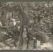
Aerial view of Haverhill, Little River, Pentucket Mills, 1929 - Print, Photographic
Aerial view of Haverhill, Little River, Pentucket Mills, 1929. Three photographs, two duplicates, 8 x 11 cm, mounted together on cardboard 26 x 36 cm. Inscription on verso: "Airplane view of Haverhill - 1929 / Little River - Railroad - Winter St." 1 & 2: Aerial view of Haverhill, Little River, Pentucket Mills. Winter Street dividing image horizontally, Little River on the left. See HG9 Senter HPH 28-379E. 3: Aerial view of Essex, Walnut and Lo...
Record Type: Photo
-
Aerial view of Haverhill, Little River, Pentucket Mills, 1929 - Print, Photographic
Aerial view of Haverhill, Little River, Pentucket Mills. Winter Street dividing image horizontally, Little River on the left. Inscription on verso: "Airplane View of Haverhill - 1929 / Little River - Pentucket Mills, Railroad." See HG9 Senter HPH 29-391D. Photo is 13 x 18 cm mounted on cardboard 26 x 36 cm.
Record Type: Photo
-
Aerial views of County Bridge and Railroad Bridge, Haverhill, 1929 - Print, Photographic
Aerial views of County Bridge and Railroad Bridge, Haverhill, 1929. Four photos, the largest 8 x 11 cm, mounted together on cardboard 26 x 36 cm. Inscription on verso: "Airplane view of Haverhill - 1929 / Railroad & County Bridges." First three photos faded. 1 & 4: Aerial view of County Bridge and Railroad Bridge, crossing the Merrimack River, looking north to Mount Washington, Silver Hill and Tilton School, Haverhill, 1929. Bradford visible at ...
Record Type: Photo
-
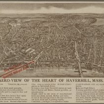
Aero-view of the Heart of Haverhill, Mass. - Print, Photomechanical
Bird's-eye view map of Haverhill, photomechanical print, promotional publication for the Haverhill National Bank. Title: "Aero-view of the Heart of Haverhill, Mass." Probably early 20th century, the new High School on Summer Street is visible. The map is printed in brown with a red arrow and the words "New Building of / Haverhill National Bank" in Washington Square. Lake Pentucket is in the upper right, the Railroad Bridge and County Bridge acros...
Record Type: Photo
-
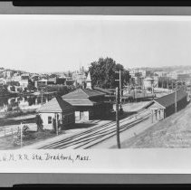
Boston & Maine Railroad, Bradford Station, Bradford, Haverhill - Negative, Sheet Film
Boston & Maine Railroad station, Bradford, Mass. Houses in the background. Caption below image: "B&M R.R. Sta. Bradford, Mass." Copy negative. Original image probably early 20th century.
Record Type: Photo
-
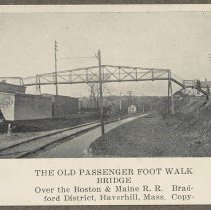
Boston & Maine Railroad footbridge, Railroad Bridge and County Bridge, Bradford - Print, Photomechanical
Boston & Maine Railroad footbridge, Railroad Bridge and County Bridge, Bradford, Haverhill. Three photomechanical prints of photographs, with captions, from an unidentified publication, mounted together on cardboard 36 x 26 cm. Housed with Historical Photographic Print Collection. 1. Footbridge over train tracks. Printed caption: "The old passenger foot walk bridge / Over the Boston & Maine R.R. Bradford District, Haverhill Mass. Copy." 7 x 9 cm...
Record Type: Photo
-
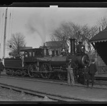
Boston & Maine Railroad locomotive at unidentified station - Negative, Glass Plate
Boston & Maine Railroad locomotive at an unidentified station or shelter. "Boston & Maine" and "South Berwick" painted on the side of the locomotive. Two men in the cabin; four men in front of the train, three wearing suits and hats, one wearing coveralls and a cap. Train tracks on wooden walkway, station or shelter on the right. Image late 19th or early 20th century.
Record Type: Photo
-
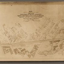
Boston & Maine Railroad, plan of abolition of grade crossings, Haverhill, 1900 - Print, Photographic
Boston & Maine Railroad, plan of abolition of grade crossings, Haverhill, 1900. The tracks are shown crossing Washington Street and Essex Street. Map title: "Plan / showing proposed changes / for the / abolition of grade crossing / Boston and Maine Railroad / Eighth Avenue - Orchard Street / Haverhill Massachusetts / March 1900 / Robert R. Evans / City Engineer / Scale 46 feet - 1 inch." Photo faded. Photo is 16 x 21 cm mounted on cardboard 28 x ...
Record Type: Photo
-
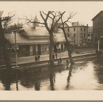
Bradford Bridge Depot during Flood of 1896 - Print, Photographic
Bradford Bridge Depot during flood. The water has risen over the tracks nearly to the depot platform. People stand in front of the depot.1896.
Record Type: Photo
-
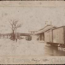
Bradford Bridge Stations at freshet of 1896, rise of Merrimack River - Postcard
Merrimack River flooding from 1896 freshet, near Boston & Maine Railroad bridge from Haverhill to Bradford and the Bradford Station. Station building at right, bridge in distance. Postcard "Compliments of Rowe & Emerson Clothiers" of Haverhill. "S. M. Smith" inscribed on verso. 1896.
Record Type: Photo
-
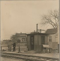
Bradford crossing before new bridge was erected, c. 1901 - Print, Photographic
Bradford crossing, looking toward South Elm Street from Bradford Station before the new railroad bridge was built. An attendant stands with a hand on the switch left of the railroad hut by the crossing. Photo by W. P. Johnson, circa 1901.
Record Type: Photo