Person Record
Metadata
Name |
McFarland, James C. |
Related Records
-
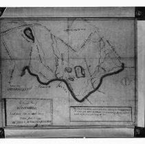
Accurate Plan of Haverhill Laid down from an actual Survey Taken June 1st 1795 - Negative, Glass Plate
Map of Haverhill, 1795. Title: "An Accurate Plan of Haverhill Laid down from an actual Survey Taken June 1st 1795 by James C. McFarland & Josiah Noyes." Shows roads, rivers, ponds, bridges, ferries and mills. With scale of rods to miles. Mass. Archives inkstamp on the right. Black and white negative. See article by Mabel D. Mason, HK1.2 Senter HPH 56-784A.
Record Type: Photo
-
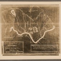
Accurate Plan of Haverhill Laid down from an actual Survey Taken June 1st 1795 - Print, Photographic
Map of Haverhill, 1795. Title: "An Accurate Plan of Haverhill Laid down from an actual Survey Taken June 1st 1795 by James C. McFarland & Josiah Noyes." Shows roads, rivers, ponds, bridges, ferries and mills. With scale of rods to miles. Photograph of a photostat, probably the copy held by the Haverhill Historical Society. See glass negative HK1.2 Senter G5x7 7-29. Photo is 13 x 15 cm mounted on cardboard 26 x 36 cm.
Record Type: Photo
-
Map of Haverhill 1795, article by Mabel D. Mason, Echoes From "The Buttonwoods" - Photocopy
Article concerning the oldest map of Haverhill (1795), by Mabel D. Mason, from the "Echoes From 'The Buttonwoods'" column. The article is eleven paragraphs in two columns. The map discussed in the article is "An Accurate Plan of Haverhill Laid down from an actual Survey Taken June 1st 1795 by James C. McFarland & Josiah Noyes," see HK1.2 Senter G5x7 7-29. The article describes the map's features including bridges, rivers, ponds, streams, mills, s...
Record Type: Photo