
Photo Record
Images
Metadata
Title |
Aerial views of Haverhill, 1929 |
Object Type |
Print, Photographic |
Description |
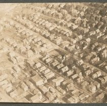
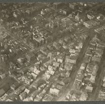
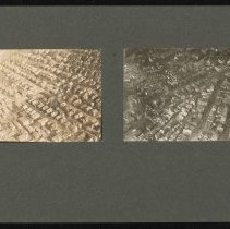
Aerial views of Haverhill, 1929. Two photos, 8 x 11 cm, mounted together on cardboard 18 x 28 cm. Inscription on verso: "Airplane view of Haverhill - 1929 / (left) Nichols, North, Franklin Sts (Right) Emerson - How - Pecker Sts." 1. Aerial view of Haverhill, residential area with Nichols Street, North Avenue, Franklin Street and Primrose Street. Inscription on verso of duplicate print HG9 Senter HPH 28-389C: "Airplane view of Haverhill - 1929 / Sections of Nichols, North, Franklin & Primrose Sts." Faded. 2. Aerial view of Haverhill, Emerson Street and How Street, 1929. Emerson Street runs diagonally on the left, How Street to the right, and they almost meet in a V at the intersection with Winter Street. Inscription on verso of duplicate print HG9 Senter HPH 28-387C: "Airplane View of Haverhill - 1929 / Emerson St (center) - How St (next right)." |
Date |
1929 |
Processing Method |
Gelatin silver print |
Print size |
8 x 11 cm |
Call Number |
Senter HPH 28-390B |
Catalog Number |
31479006485717 |
Classification |
HD1 Description / Aerial Views / Birdseye Views |
Subjects |
Haverhill (Mass.) Architecture |
Place |
Haverhill, MA |
Search Terms |
Haverhill Emerson Street How Street Winter Street Streets Architecture Aerial views |
Collection |
Haverhill History Collection |
Provenance |
Found in collection. |
Digital Collection |
Senter Digital Archive |
Copyright Statement |
Copyright is not held by the Haverhill Public Library. The library retains custodial rights. |
Related Records |
Show Related Records... |
Last Updated |
2020-12-14 |