Search Term Record
Metadata
Search Term |
Silver Hill |
Number of Object records |
0 |
Number of Photo records |
121 |
Number of Archive records |
0 |
Number of Library records |
0 |
Related Records
-
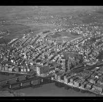
Aerial view of County Bridge and Railroad Bridge, looking north, Haverhill, 1929 - Negative, Glass Plate
Aerial view of County Bridge and Railroad Bridge, crossing the Merrimack River, looking north to Mount Washington, Silver Hill and Tilton School, Haverhill, 1929. Bradford visible at lower left. See HG9 Senter HPH 28-389E, 28-390E.
Record Type: Photo
-
Aerial view of County Bridge and Railroad Bridge, looking north, Haverhill, 1929 - Print, Photographic
Aerial view of County Bridge and Railroad Bridge, looking north to Mount Washington, Silver Hill and Tilton School, Haverhill, 1929. Inscription on verso: "Airplane view of Haverhill - 1929 / Railroad & County Bridges - Silver Hill in distance." See HG9 Senter G4x5 3-28, HG9 Senter HPH 28-389E. Photo is 14 x 18 cm mounted on cardboard 26 x 36 cm.
Record Type: Photo
-
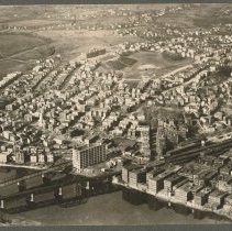
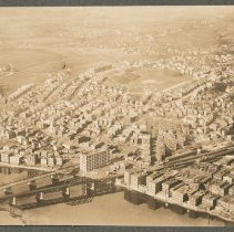
Aerial view of Haverhill and Bradford - Print, Photographic
Aerial view of Haverhill and Bradford. Bradford (south) on the left, Haverhill (north) on the right. Hales Island visible on the left in the Merrimack River. Image probably circa 1930, Tilton's Tower on Silver Hill visible near top of image. Stamped on verso: "Cheyne Aerial Surveys / 42 Summer St. / Methuen, Mass." Snapshot photograph.
Record Type: Photo
-
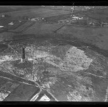
Aerial view of Tilton's Tower, Silver Hill, Haverhill, 1929 - Negative, Glass Plate
Aerial view of Silver Hill and Tilton's Tower, Haverhill, 1929. The tower had a square base and tapered toward the top; it stood ten stories and had an observation level at the top. It was built in 1887 by John Cooper Tilton of Newbury, and stood until 1945. View looking North toward Lowell Avenue. Glass broken. Tilton's Tower stood from 1887 to 1945.
Record Type: Photo
-
Aerial view of Tilton's Tower, Silver Hill, Haverhill, 1929 - Print, Photographic
Aerial view of Silver Hill and Tilton's Tower, Haverhill, 1929. The tower had a square base and tapered toward the top; it stood ten stories and had an observation level at the top. It was built in 1887 by John Cooper Tilton of Newbury, and stood until 1945. Inscription on verso: "Airplane View of Haverhill - 1929 / Tilton's Tower (Silver Hill)." Two duplicate photos, faded, 8 x 11 cm, mounted together on cardboard 18 x 28 cm.
Record Type: Photo
-
Aerial view of Tilton's Tower, Silver Hill, Haverhill, 1929 - Print, Photographic
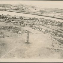
Aerial view of Tilton's Tower, Silver Hill, Haverhill, looking south, 1929. The tower had a square base and tapered toward the top; it stood ten stories and had an observation level at the top. It was built in 1887 by John Cooper Tilton of Newbury, and stood until 1945. Houses, streets and fields visible, Merrimack River and Bradford at the top. Photo is 21 x 26 cm mounted on cardboard 26 x 36 cm.
Record Type: Photo
-
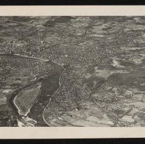
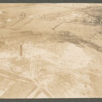
Aerial views of County Bridge and Railroad Bridge, Haverhill, 1929 - Print, Photographic
Aerial views of County Bridge and Railroad Bridge, Haverhill, 1929. Four photos, the largest 8 x 11 cm, mounted together on cardboard 26 x 36 cm. Inscription on verso: "Airplane view of Haverhill - 1929 / Railroad & County Bridges." First three photos faded. 1 & 4: Aerial view of County Bridge and Railroad Bridge, crossing the Merrimack River, looking north to Mount Washington, Silver Hill and Tilton School, Haverhill, 1929. Bradford visible at ...
Record Type: Photo
-
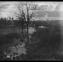
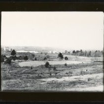
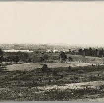
Field, Tilton's Tower in background, Haverhill - Negative, Glass Plate
Fields, trees, houses, with Tilton's Tower and Silver Hill in the background, Tilton School and water tower to the left. Emulsion damaged. Image probably late 19th century after 1887, when Tilton's Tower was built.
Record Type: Photo
-
Hale Hospital, Buttonwoods Avenue, Haverhill - Transparency, Lantern Slide
Hale Hospital, Buttonwoods Avenue, Haverhill. Four buildings. Bird's eye view, with Merrimack River and Haverhill Bridge, Downtown Haverhill and Bradford in the background, hill and fields in the foreground. Tilton's Tower on Silver Hill in the distance. Image probably early 20th century.
Record Type: Photo
-
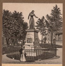
Hannah Duston Statue, Tilton's Tower, Soldiers' Monument, Haverhill - Print
Hannah Duston Statue, Tilton's Tower, Soldiers' Monument, Haverhill. Three prints, different sizes, mounted together on cardboard 26 x 36 cm. Yellow or buff caption area, printed in black ink. From an unidentified publication. Housed with Historical Photographic Print Collection. 1. Hannah Duston Statue, City Hall Park (later G.A.R. Park), Haverhill. View of front and right sides. Duston has long hair, is wearing a long dress, is pointing with h...
Record Type: Photo
-
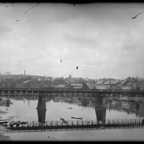
Haverhill Bridge, Haverhill - Negative, Glass Plate
Haverhill Bridge, Merrimack River, Haverhill. Bradford shore on the left, Haverhill on the right. This iron version of the bridge stood from 1873-1925. Small boats on the shore and moored in the river. Silver Hill and Tilton's Tower in the background. Image probably late 19th century after 1887, when Tilton's Tower was built. Photographer may be W. Orin Tasker.
Record Type: Photo
-
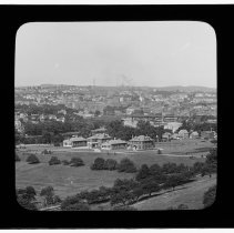
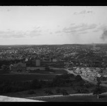
Haverhill, looking east from Tilton's Tower, Silver Hill - Negative, Glass Plate
Haverhill, looking east from Tilton's Tower, Silver Hill. Probably the Tilton School under construction on the left. Water or gas tank near center of frame. Tilton's Tower stood from 1887 to 1945. Photo by Thomas Bailey, late 19th or early 20th century.
Record Type: Photo
-
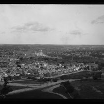
Haverhill, looking east from Tilton's Tower, Silver Hill - Negative, Glass Plate
Haverhill, looking east from Tilton's Tower, Silver Hill. Merrimack River, Haverhill Bridge, Bradford in the background. Tilton's Tower stood from 1887 to 1945. Image late 19th or early 20th century, probably by Thomas Bailey.
Record Type: Photo
-
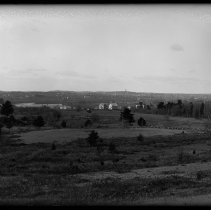
Haverhill, view from Groveland, ca. 1892 - Negative, Glass Plate
Haverhill, view from Groveland across the Merrimack River. Fields, houses in Groveland in the foreground. Haverhill, Silver Hill and Tilton's Tower in the distance. Photo by Charles C. Osgood, circa 1892-93. See prints HG9 Senter HPH 27-375B, 29-393K.
Record Type: Photo
-
Haverhill, view from Groveland, ca. 1892 - Print, Photographic
Haverhill, view from Groveland across the Merrimack River. Fields, houses in Groveland in the foreground. Haverhill, Silver Hill and Tilton's Tower in the distance. Original photo by Charles C. Osgood, circa 1892-93; this is a 20th century copy. See glass negative HG9 Senter G6x8 11-7, print HG9 Senter HPH 27-375B.
Record Type: Photo
-
Haverhill, view from Groveland, ca. 1892 - Print, Photographic
Haverhill, view from Groveland across the Merrimack River. Fields, houses in Groveland in the foreground. Haverhill, Silver Hill and Tilton's Tower in the distance. Inscription on verso: "Photograph by Charles C. Osgood / 1892-3 / Haverhill from Groveland." This is a later print. See glass negative HG9 Senter G6x8 11-7, print HG9 Senter HPH 29-393K. Photo is 16 x 21 cm mounted on cardboard 26 x 33 cm.
Record Type: Photo
-
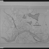
Map of downtown Haverhill and Bradford, with wards and neighborhoods - Negative, Sheet Film
Map of downtown Haverhill and Bradford. Most streets named. Inscription on housing: "Downtown 1897." Downtown Haverhill, Merrimack River and downtown Bradford. Includes bridges, railroads, streams and ponds, ward boundaries and numbers, and names of neighborhoods. Title of map on right: "1897 map of the city of Haverhill" published by W. A. Greenough & Company, Boston. Concentric circles representing quarter miles from town center / Ward 1. Name...
Record Type: Photo
-
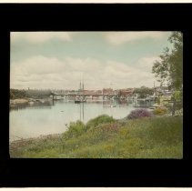
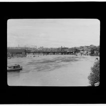
Merrimack River, Haverhill Bridge, Haverhill - Transparency, Lantern Slide
Merrimack River, Haverhill Bridge crossing; Haverhill on the right, Bradford on the left. This is the iron version which stood from 1873-1925. Boats on the river; Crescent Motor Boat Club on the right. The boat on the left in the foreground may be a tugboat. Tilton's Tower on Silver Hill in the distance on the left. Image early 20th century.
Record Type: Photo
-
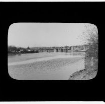
Merrimack River, Haverhill Bridge, Haverhill - Transparency, Lantern Slide
Merrimack River, Haverhill Bridge crossing; Haverhill on the right, Bradford on the left. This is the bridge built in 1925. A few boats on the river; Crescent Motor Boat Club on the right. Tilton's Tower on Silver Hill in the distance on the left. Image probably circa 1925 to 1930s.
Record Type: Photo
-
Merrimack River, schooner and Haverhill Bridge, Haverhill - Transparency, Lantern Slide
Merrimack River, schooner and Haverhill Bridge, Haverhill. Haverhill on the right, Bradford on the left. Tilton's Tower on Silver Hill in the distance on the left. Schooner with sails furled moored? in front of the Haverhill Bridge; name on stern not legible. Other small boats moored on the river. Shore with grass and shrubs in the foreground. Hand colored. Image late 19th or early 20th century, see also HL6.2 Senter GLS 7-3, GLS 11-20.
Record Type: Photo