Search Term Record
Metadata
Search Term |
Robert R. Evans |
Number of Object records |
0 |
Number of Photo records |
3 |
Number of Archive records |
0 |
Number of Library records |
0 |
Related Records
-
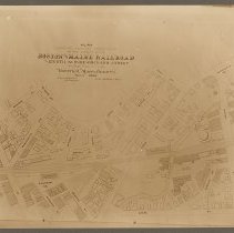
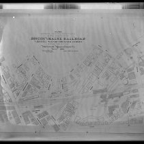
Map, Boston & Maine Railroad, Eighth Ave. to Orchard Street, Haverhill, 1900 - Negative, Glass Plate
Boston & Maine Railroad map, Haverhill, 1900. Full title: "Plan showing existing conditions in the vicinity of the Boston and Maine Railroad from Eighth Avenue to Orchard Street within the city of Haverhill, Massachusetts. March 1900." Railroad tracks, streets, buildings and properties. City Engineer: Robert R. Evans. Scale: 40 feet to 1 inch. Emulsion damaged, label on glass faded. Date of photograph early 20th century. See print HK1.8 Senter HP...
Record Type: Photo
-
Map, Boston & Maine Railroad, Eighth Ave. to Orchard Street, Haverhill, 1900 - Print, Photographic
Boston & Maine Railroad map, Haverhill, 1900. Full title: "Plan showing existing conditions in the vicinity of the Boston and Maine Railroad from Eighth Avenue to Orchard Street within the city of Haverhill, Massachusetts. March 1900." Railroad tracks, streets, buildings and properties. City Engineer: Robert R. Evans. Scale: 40 feet to 1 inch. See glass negative HK1.8 Senter G6x8 14-16. Photo is 15 x 21 cm mounted on cardboard 27 x 31 cm.
Record Type: Photo