Search Term Record
Metadata
Search Term |
Railroad tracks |
Number of Object records |
0 |
Number of Photo records |
129 |
Number of Archive records |
0 |
Number of Library records |
0 |
Related Records
-
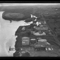
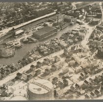
Aerial view of Box Board Company, Oil Tanks, and Hales Island, Bradford, 1929 - Negative, Glass Plate
Aerial view of Haverhill Box Board Company, Standard Oil Tanks, and Hales Island, looking East, Bradford, Haverhill, 1929. Merrimack River on the left, railroad tracks on the right.
Record Type: Photo
-
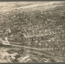
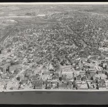
Aerial view of Bradford, Haverhill, 1929 - Print, Photographic
Aerial view of Bradford, Haverhill, 1929. Bradford Depot / Bradford Station and railroad tracks at the bottom of the image, with train on the left. The steeple of the First Church of Christ, also known as the White Church, is visible near the upper right. The Merrimack River and Haverhill (north) are at the top of the image. Photo is 14 x 19 cm mounted on cardboard 26 x 36 cm.
Record Type: Photo
-
Aerial view of Downtown Haverhill ca. 1960 - Print, Photographic
Aerial view of Downtown Haverhill circa 1960. Post Office at bottom left in Washington Square, Merrimack Street running horizontally to the right. Railroad tracks on the left. Inscription on similar photo verso: "Photo circa 1960," see HG9 Senter HPH 28-380C.
Record Type: Photo
-
Aerial view of Downtown Haverhill ca. 1960 - Print, Photographic
Aerial view of Downtown Haverhill circa 1960. Post Office at bottom left in Washington Square, Merrimack Street running horizontally to the right. Railroad tracks on the left. Inscription on verso: "Photo circa 1960." See also HG9 Senter HPH 28-380E.
Record Type: Photo
-
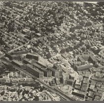
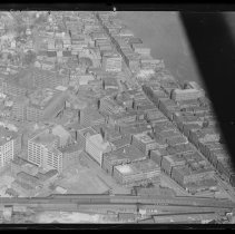
Aerial view of Essex, Walnut and Locust Streets, Haverhill, 1929 - Negative, Glass Plate
Aerial view of Essex, Walnut and Locust Streets, looking north, Haverhill, 1929. Shoe district buildings, houses, churches. See prints HG9 Senter HPH 28-388E, 29-391D.
Record Type: Photo
-
Aerial view of Essex, Walnut and Locust Streets, Haverhill, 1929 - Print, Photographic
Aerial view of Essex, Walnut and Locust Streets, looking north, Haverhill, 1929. Shoe district buildings, houses, churches. Railroad tracks on the left. Inscription on verso: "Airplane View of Haverhill - 1929 / Essex St. (left) - R.R." See glass negative HG9 Senter G4x5 3-9, print HG9 Senter HPH 29-391D. Photo is 14 x 18 cm mounted on cardboard 26 x 36 cm.
Record Type: Photo
-
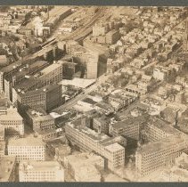
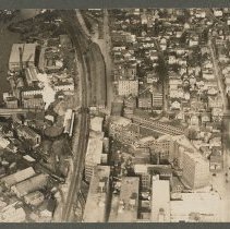
Aerial view of Haverhill, 1935 - Print, Photographic
Aerial view of downtown shoe district, multistory factory buildings on Essex Street, Boston and Maine Railroad tracks, Haverhill, 1935. Inscription on verso: "Photo by Arthur H. Moran / Airplane view of Haverhill - 1935." Photo is 15 x 21 cm mounted on cardboard 26 x 36 cm.
Record Type: Photo
-
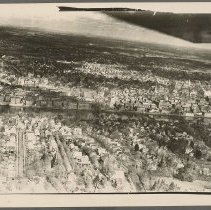
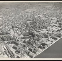
Aerial view of Haverhill and Bradford, 1929 - Print, Photographic
Aerial view of Haverhill and Bradford, 1929. Bradford (south) is at the bottom, Haverhill (north) is across the Merrimack River. Railroad tracks and a small bit of the Railroad Bridge visible on the left. Dark area upper right may be airplane wing. Inscription on verso: "Airplane view of Haverhill - 1929." Photo is 21 x 26 cm mounted on cardboard 26 x 36 cm.
Record Type: Photo
-
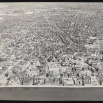
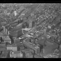
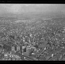
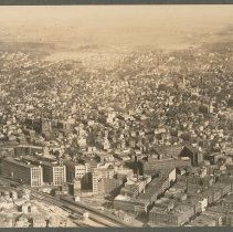
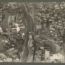
Aerial view of Haverhill, downtown shoe district and railroad, 1929 - Negative, Glass Plate
Aerial view of Haverhill, downtown shoe district and railroad, 1929. Railroad tracks and train at bottom, Merrimack River on the right. Part of airplane on the right. Some damage to negative emulsion. One print in our file dates this as 1929, another is attributed to Arthur H. Moran and dated 1935 on verso, see cropped verison print HG9 Senter HPH 25-344B.
Record Type: Photo
-
Aerial view of Haverhill from railroad lines to Round Pond / Lake Pentucket, 1929 - Negative, Glass Plate
Aerial view of Haverhill, from railroad lines to Round Pond / Lake Pentucket (in the distance at top of image), 1929. St. James Church visible center left. See print HG9 Senter HPH 28-387D.
Record Type: Photo
-
Aerial view of Haverhill from railroad lines to Round Pond / Lake Pentucket, 1929 - Print, Photographic
Aerial view of Haverhill, from railroad lines and factory buildings on Essex Street to Round Pond / Lake Pentucket (in the distance at top of image), 1929. St. James Church visible center left. See glass negative HG9 Senter G4x5 3-13. Photo is 13 x 18 cm mounted on cardboard 26 x 36 cm.
Record Type: Photo
-
Aerial view of Haverhill, Little River, Hilldale Avenue, 1929 - Print, Photographic
Aerial view of Haverhill, Little River, Hilldale Avenue, 1929. Little River with railroad tracks above, Hilldale Avenue below, storage tanks one with "Haverhill" on the top, Lafayette Square, Essex Street and Broadway on the right. Inscription on verso: "Airplane view of Haverhill - 1929." Photo is 19 x 25 cm mounted on cardboard 26 x 36 cm.
Record Type: Photo
-
Aerial view of Haverhill, Little River, Pentucket Mills, 1929 - Print, Photographic
Aerial view of Haverhill, Little River, Pentucket Mills, 1929. Three photographs, two duplicates, 8 x 11 cm, mounted together on cardboard 26 x 36 cm. Inscription on verso: "Airplane view of Haverhill - 1929 / Little River - Railroad - Winter St." 1 & 2: Aerial view of Haverhill, Little River, Pentucket Mills. Winter Street dividing image horizontally, Little River on the left. See HG9 Senter HPH 28-379E. 3: Aerial view of Essex, Walnut and Lo...
Record Type: Photo
-
Aerial view of Haverhill, Little River, Pentucket Mills, 1929 - Print, Photographic
Aerial view of Haverhill, Little River, Pentucket Mills. Winter Street dividing image horizontally, Little River on the left. Inscription on verso: "Airplane View of Haverhill - 1929 / Little River - Pentucket Mills, Railroad." See HG9 Senter HPH 29-391D. Photo is 13 x 18 cm mounted on cardboard 26 x 36 cm.
Record Type: Photo
-
Aerial view of Haverhill prior to Urban Renewal, ca. 1962 - Print, Photographic
Aerial view of Haverhill prior to Urban Renewal, circa 1962. Merrimack River at bottom right, industrial buildings and railroad tracks on the left. Washington Street and Washington Square visible, Merrimack Street on the right. Inscription on verso: "Aerial view - for Urban Renewal / View taken 1962-63 / Pentucket Club standing / Haverhill Savings Bank remodeled 1961."
Record Type: Photo
-
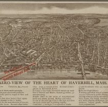
Aero-view of the Heart of Haverhill, Mass. - Print, Photomechanical
Bird's-eye view map of Haverhill, photomechanical print, promotional publication for the Haverhill National Bank. Title: "Aero-view of the Heart of Haverhill, Mass." Probably early 20th century, the new High School on Summer Street is visible. The map is printed in brown with a red arrow and the words "New Building of / Haverhill National Bank" in Washington Square. Lake Pentucket is in the upper right, the Railroad Bridge and County Bridge acros...
Record Type: Photo
-
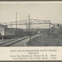
Boston & Maine Railroad footbridge, Railroad Bridge and County Bridge, Bradford - Print, Photomechanical
Boston & Maine Railroad footbridge, Railroad Bridge and County Bridge, Bradford, Haverhill. Three photomechanical prints of photographs, with captions, from an unidentified publication, mounted together on cardboard 36 x 26 cm. Housed with Historical Photographic Print Collection. 1. Footbridge over train tracks. Printed caption: "The old passenger foot walk bridge / Over the Boston & Maine R.R. Bradford District, Haverhill Mass. Copy." 7 x 9 cm...
Record Type: Photo
-
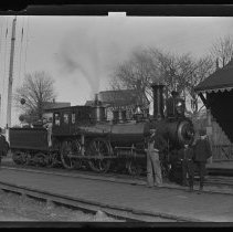
Boston & Maine Railroad locomotive at unidentified station - Negative, Glass Plate
Boston & Maine Railroad locomotive at an unidentified station or shelter. "Boston & Maine" and "South Berwick" painted on the side of the locomotive. Two men in the cabin; four men in front of the train, three wearing suits and hats, one wearing coveralls and a cap. Train tracks on wooden walkway, station or shelter on the right. Image late 19th or early 20th century.
Record Type: Photo
-
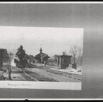
Bradford Station, Bradford, Haverhill - Photocopy
Bradford Station, Bradford, Haverhill. Locomotive facing the camera with steam on the left. Several men standing in front of the station o the right, one man in the foreground. Station is one story with cupola and weathervane. Two shacks, one on each side of the tracks. Lever in the foreground on the left. Houses in the background. Photocopy of a photograph. Housed with Historical Photographic Print Collection.
Record Type: Photo