Search Term Record
Metadata
Search Term |
Lakes |
Number of Object records |
0 |
Number of Photo records |
454 |
Number of Archive records |
0 |
Number of Library records |
0 |
Related Records
-
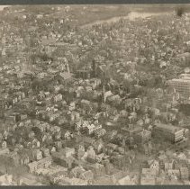
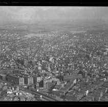
Aerial view, Main Street and Monument Square, Haverhill, 1929 - Print, Photographic
Aerial view, Main Street and Monument Square, Haverhill, 1929. The rear of North Congregational Church and the left side of the First Universalist Church are visible with Monument Square to the left, and Haverhill High School is on the right at the corner of Summer Street. Lake Saltonstall is near the top of the frame. Inscription on verso: Airplane view of Haverhill - 1929 / North Church (center) - High School (right)." Photo is 14 x 19 cm mount...
Record Type: Photo
-
Aerial view of Fox School, Lawrence Street, looking East, Haverhill, 1929 - Negative, Glass Plate
Aerial view of Charles K. Fox School and Lawrence Street, looking East toward Round Pond and Kenoza Lake, Haverhill, 1929. The school is on Elm Street. School in foreground, Kenoza Lake and Round Pond in the distance.
Record Type: Photo
-
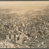
Aerial view of Haverhill, 1929 - Print, Photographic
Aerial view of Haverhill, 1929. A large storage tank is in the center of the image. Crystal Lake is at the top of the image. The photo is dampstained. Inscription on verso: "Airlane View of Haverhill - 1929 / North Broadway & Crystal Lake in distance." Photo is 13 x 18 cm mounted on cardboard 26 x 36 cm.
Record Type: Photo
-
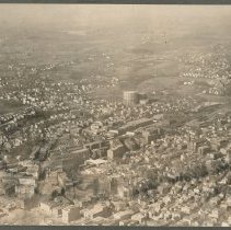
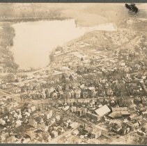
Aerial view of Haverhill from railroad lines to Round Pond / Lake Pentucket, 1929 - Negative, Glass Plate
Aerial view of Haverhill, from railroad lines to Round Pond / Lake Pentucket (in the distance at top of image), 1929. St. James Church visible center left. See print HG9 Senter HPH 28-387D.
Record Type: Photo
-
Aerial view of Haverhill from railroad lines to Round Pond / Lake Pentucket, 1929 - Print, Photographic
Aerial view of Haverhill, from railroad lines and factory buildings on Essex Street to Round Pond / Lake Pentucket (in the distance at top of image), 1929. St. James Church visible center left. See glass negative HG9 Senter G4x5 3-13. Photo is 13 x 18 cm mounted on cardboard 26 x 36 cm.
Record Type: Photo
-
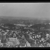
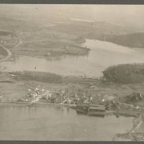
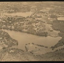
Aerial view of Haverhill, Round Pond / Lake Pentucket, Kenoza Lake, 1929 - Print, Photographic
Aerial view of Haverhill, Round Pond (Lake Pentucket) and Kenoza Lake, 1929. Round Pond is in the foreground, with Kenoza Lake in the background. Kenoza Avenue forks into Newton Road (far left) and Amesbury Road (right) which in turn forks to Kenoza Street (right). The Round Pond icehouse is visible on the shore. Inscription on verso: "Airplane view of Bradford - 1929 / Bradford Academy," an error. Photo is 14 x 18 cm mounted on cardboard 26 x 36...
Record Type: Photo
-
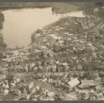
Aerial view of Lake Saltonstall / Plug Pond, Haverhill, 1929 - Print, Photographic
Aerial view of Lake Saltonstall, also known as Plug Pond, Haverhill, 1929. Kenoza Avenue is the street running diagonally on the left, Mill Street runs close to the lake. Inscription on verso: "Airplane view of Haverhill - 1929 / Lake Saltonstall - Mill St. - Kenoza Ave." Photo is 13 x 18 cm mounted on cardboard 26 x 36 cm.
Record Type: Photo
-
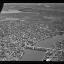
Aerial view of Merrimack Street and Water Street, Haverhill, 1929 - Negative, Glass Plate
Aerial view of Merrimack Street and Water Street, Haverhill, looking east toward White's Corner and bridge. Merrimack River and Haverhill Bridge on the right, lakes in the distance. Part of aircraft window frame on left. Image probably from 1929. Some damage to negative emulsion.
Record Type: Photo
-
Aerial view of Plug Pond / Lake Saltonstall, Winnekenni Basin and Round Pond, Haverhill - Print, Photographic
Aerial view of Plug Pond / Lake Saltonstall, Winnekenni Basin and Round Pond / Lake Pentucket, Haverhill. Inscription on verso: "Plug Pond lower end / Winnekenni Basin to right / Round Pond @ top." A patron has identified the water on the right as Kenoza Lake, not Winnekenni Basin. Photo by Arthur H. Moran, probably circa 1935. Inkstamp on verso: "A. H. Moran / P. O. Box 283 / Haverhill, Mass."
Record Type: Photo
-
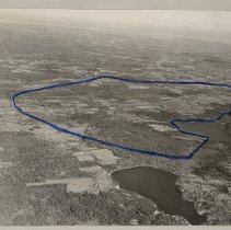
Aerial view, proposed site of electron volt accelerator, Haverhill, 1966 - Print, Photographic
Aerial view, proposed site of an electron volt accelerator, Haverhill, 1966. Route of proposed accelerator marked in dark blue pen. The 1966 Journal of the Senate of the United States of America, Second Session of the Eighty-Ninth Congress, January 14, noted "A resolution favoring the selection of the city of Haverhill, Mass., as the location for the Atomic Energy Commission's proposed 200 billion electron volt accelerator; to the Joint Commissio...
Record Type: Photo
-
Aerial views of Lake Saltonstall / Plug Pond, Haverhill, 1929 - Print, Photographic
Aerial views of Lake Saltonstall, also known as Plug Pond, Haverhill, 1929. Two duplicate photos, 9 x 11 cm, mounted together on cardboard 18 x 26 cm. Kenoza Avenue, left, and Mill Street, next to the lake, meet at Gale Park on the left. Inscription on verso: "Airplane view of Haverhill - 1929 / Lake Saltonstall." There is a black finger mark in the upper right corner of both photos; the photo on the left is faded.
Record Type: Photo
-
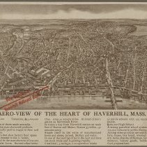
Aero-view of the Heart of Haverhill, Mass. - Print, Photomechanical
Bird's-eye view map of Haverhill, photomechanical print, promotional publication for the Haverhill National Bank. Title: "Aero-view of the Heart of Haverhill, Mass." Probably early 20th century, the new High School on Summer Street is visible. The map is printed in brown with a red arrow and the words "New Building of / Haverhill National Bank" in Washington Square. Lake Pentucket is in the upper right, the Railroad Bridge and County Bridge acros...
Record Type: Photo
-
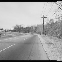
Amesbury Road, Haverhill - Negative, Sheet Film
Amesbury Road, Haverhill. Four lane road, two lanes in each direction. Sign for intersection with Route 108 in background. Lake on left, trees on right, houses in background.
Record Type: Photo
-
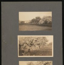
Apple Blossoms near Kenoza Lake, 1924 - Print, Photographic
Three photographs of apple trees near Kenoza Lake, each featuring a full bloom of apple blossoms. Kenoza Lake visible in the background of the top photo. Photographer Howard W. Kimball, 1924.
Record Type: Photo
-
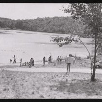
Beach, probably Plug Pond / Lake Saltonstall, Haverhill, 1974 - Print, Photographic
Beach, probably Plug Pond / Lake Saltonstall, Haverhill. Children, boys and girls, on the shore of a lake or pond. some are in bathing suits, some are fishing, one with a dog on the beach, one in the water in the roped-off area. Car and tree on the right. Lake in the background with trees on the shore. Inscription on verso: [crop details for newspaper, probably Haverhill Gazette] "Mon July 29, 1974 / The Waterfront."
Record Type: Photo
-
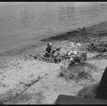
Boy building sand castles, beach at unidentified lake - Negative, Roll Film
A young boy with fair hair is building sand castles, at a beach at an unidentified lake or pond. Another young boy is in one photo, and in several photos the shoreline with trees, docks, boats and houses is visible. Multiple images. Photos from the Haverhill Gazette, circa late 1970s-1980.
Record Type: Photo
-
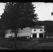
Boyd B. Jones House garage, Mill Street, Haverhill - Negative, Glass Plate
Garage of Boyd B. Jones House, 247 Mill Street, Haverhill. Two stories with hip roof, pale clapboard, two garage doors painted a dark color. Wire fence on the left, wooden picket fence on the right. Inscription with print in file: "Garage of Boyd B. Jones House - converted into residence by Ruth & Eleanor Jones after the big house [243] was torn down." Street in the foreground, Plug Pond/Lake Saltonstall in background.
Record Type: Photo
-
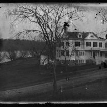
Boyd B. Jones House, Mill Street, Haverhill - Negative, Glass Plate
Boyd B. Jones House, 243 Mill Street, Haverhill. Four stories including partially exposed basement level. Clapboard, dark shutters, bay window on first story. Porch on right side of house with balcony above on second story. Street in the foreground, Plug Pond/Lake Saltonstall in background on the left. Inscription with print in file: "Torn down - when Boyd B. Jones purchased this property there was an older house on the site. It was incorporated ...
Record Type: Photo
-
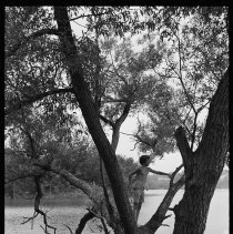
Boy in a tree, next to a lake - Negative, Roll Film
Boy in a tree, next to a lake or pond. He is wearing shorts and the tree is extending out over the water. Houses on the far shore in the background. Lake or pond and boy not identified. Multiple images. Photos from the Haverhill Gazette, circa late 1970s-1980.
Record Type: Photo
-
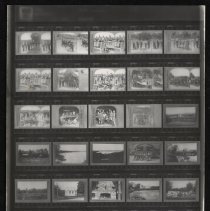
Boy Scouts, Lone Tree Camp, Deerfield, N.H., contact sheet - Print, Photographic
Boy Scouts, Lone Tree Camp, Deerfield, New Hampshire, 35mm contact sheet with thirty images. Lone Tree Camp in Deerfield ceased operations in the 1940s, and was replaced by the Lone Tree Scout Reservation in Kingston, New Hampshire. Images include Boy Scouts in uniform at cabins or tents, boys in swimsuits by Lake Pleasant and photos of the lake; camp buildings including Infirmary and an interior with a stone fireplace; a dock with boys in bathin...
Record Type: Photo