Search Term Record
Metadata
Search Term |
Improvements |
Number of Object records |
0 |
Number of Photo records |
34 |
Number of Archive records |
0 |
Number of Library records |
0 |
Related Records
-
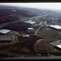
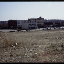
Aerial view of Bradford, Haverhill, 1977 - Transparency, Slide
Aerial view, Ward Hill, Bradford, Haverhill. Several large commercial buildings, highway and access roads, water tank on the left on the hill. Inscription on slide mount: "WHIP WEST / EC DEV." Date on slide: Nov 77, number 27.
Record Type: Photo
-
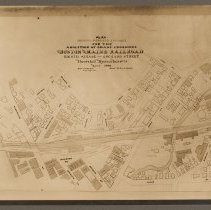
Boston & Maine Railroad, plan of abolition of grade crossings, Haverhill, 1900 - Print, Photographic
Boston & Maine Railroad, plan of abolition of grade crossings, Haverhill, 1900. The tracks are shown crossing Washington Street and Essex Street. Map title: "Plan / showing proposed changes / for the / abolition of grade crossing / Boston and Maine Railroad / Eighth Avenue - Orchard Street / Haverhill Massachusetts / March 1900 / Robert R. Evans / City Engineer / Scale 46 feet - 1 inch." Photo faded. Photo is 16 x 21 cm mounted on cardboard 28 x ...
Record Type: Photo
-
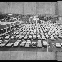
Central Plaza, opening day, Haverhill, 1972 - Negative, Sheet Film
Central Plaza, Haverhill, opening day, 1972. Parking lot and stores Zayre and DeMoulas seen from elevated position; lot is full. Inscription with print in file: "Central Plaza on opening day in 1972 corner of Main & Water Streets."
Record Type: Photo
-
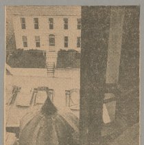
City Hall tower roof, clock, and bell, Main Street, Haverhill, 1955 - Print, Photomechanical
City Hall tower roof, clock, and bell, Main Street, Haverhill, 1955. Inscription on verso: "City Hall Clock - 1955." Three newsclippings from the Haverhill Gazette, 15 x 10 cm, mounted together on cardboard 26 x 33 cm. Call number is HH12.3.3 Senter HPH 62-867B. 1. View looking down on onion-shaped roof detail, house and cars below. Printed caption: "Tower Topper - The large metal ball which once decorated the City Hall tower is shown here at r...
Record Type: Photo
-
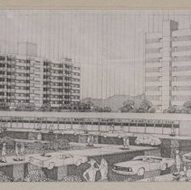
Commercial Housing Project, proposal, White's Corner, Haverhill, 1972 - Print, Photographic
Commercial Housing Project, proposal, White's Corner, Haverhill, 1972. Photograph of a monochrome drawing, proposed pair of apartment towers, ten stories. The DeMoulas shopping plaza (Central Plaza) is in the foreground, with cars and pedestrians; foliage in the foreground, hills in the distance. The drawing is not signed but this is a photograph of the drawing, could be cropped. Inscription on verso: "White's Corner / Proposed Plan: / $5 million...
Record Type: Photo
-
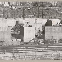
Construction, commercial and apartment building, Water Street, Haverhill - Print, Photographic
Construction, commercial and apartment building, One Water Street at White's Corner, Haverhill. Foundation walls present, view from Merrimack River. Undated (circa 1972). Inscription on verso: "Water Street / Foundation construction of High rise commercial and apartment at White's Corner." Photo is 12 x 22 cm mounted on cardboard 26 x 36 cm.
Record Type: Photo
-
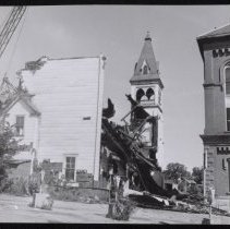
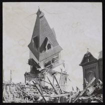
Demolition of Church of the Nazarene, Haverhill, 1972 - Print, Photographic
Demolition of Church of the Nazarene, Urban Renewal program, Winter Street (rear), Haverhill, 1972. Crane on left, building mostly demolished, tower and steeple still standing. City Hall on the right. Inscription on verso: "Nazarene Church being demolished for urban renewal 1972 / city hall in the background / Formerly located next to City Hall and opposite lower end of G.A.R. park." See also HH19.3 Senter HPH 20-282C, 282E.
Record Type: Photo
-
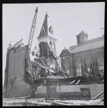
Demolition of Church of the Nazarene, Haverhill, 1972 - Print, Photographic
Demolition of Church of the Nazarene, Urban Renewal program, Winter Street (rear), Haverhill, 1972. Steeple of church falling. City Hall on the right. Inscription on verso: "Nazarene Church demolished for urban renewal / City Hall in background." Staining to photo. See also HH19.3 Senter HPH 20-282C, 282D.
Record Type: Photo
-
Demolition of Church of the Nazarene, Haverhill, 1972 - Print, Photographic
Demolition of Church of the Nazarene, Urban Renewal program, Winter Street (rear), Haverhill, 1972. Crane on left, building mostly demolished. Steeple and old City Hall (Main Street) clock in background. Inscription on verso: "Nazarene Church demolished for urban renewal 1972 / city hall in the background / Church was on Main St opposite lower end of GAR park." See also HH19.3 Senter HPH 20-282D, 282E.
Record Type: Photo
-
Demolition of old City Hall, urban renewal, Haverhill, 1973 - Negative, Sheet Film
Demolition of old City Hall, Haverhill, under Urban Renewal program. Truck with name of wrecking company, Jay-Mor Wrecking, with crane in foreground. Car parked in foreground front of truck. Original image taken in 1973.
Record Type: Photo
-
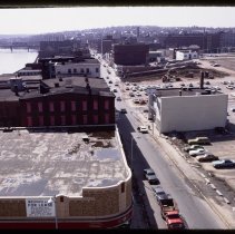
Downtown Haverhill, Urban Renewal, 1977 - Transparency, Slide
Downtown Haverhill, Urban Renewal construction with empty lots behind Merrimack Street buildings. Bird's-eye view looking west down Merrimack Street. F. W. Woolworth building with "For Lease" sign on the left, with the Merrimack River, Railroad Bridge and Comeau Bridge in the distance. Date on slide: Apr 77, number 28.
Record Type: Photo
-
Downtown Haverhill, Urban Renewal, empty lot, 1977 - Transparency, Slide
View of empty lot north of Merrimack Street, Downtown Haverhill. The rear of the buildings are visible in the background. Date on slide: Apr 77, number 20.
Record Type: Photo
-
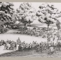
G.A.R. Park, proposed new bandstand, Haverhill, 1972 - Print, Photographic
G.A.R. Park, proposed new bandstand or bandshell, Haverhill, 1972. Black and white photograph of an architectural rendering, showing a bandstand on the left, open sides with slanted trapezoidal roof on posts. A band is shown on the bandstand, with a crowd of people, some on picnic blankets on the grass, some walking. Trees in the background. The image probably appeared in the Haverhill Gazette. Printed caption mounted below: "Expanded GAR Park, t...
Record Type: Photo
-
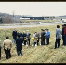
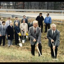
Groundbreaking, Mayor William H. Ryan and group of people, Haverhill, 1982 - Transparency, Slide
Groundbreaking, Mayor William H. Ryan and a group of people, Haverhill. They are standing outside on a grassy area near a street with a guard rail. A low building is in the background. Six people including the Mayor, four men and a woman have shovels, some are holding hard hats. The project, location and other people are not identified. See also HH19 Senter S35 2-7I, 3-7Q. Date on slide: Dec 82, number 7.
Record Type: Photo
-
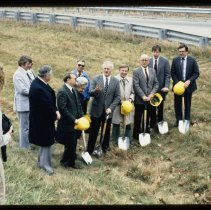
Groundbreaking, Mayor William H. Ryan and ten people, Haverhill, 1982 - Transparency, Slide
Groundbreaking, Mayor William H. Ryan and ten people, Haverhill. They are standing outside on a grassy area near a street with a guard rail. A photographer, a woman, is taking photos on the left. Six people including the Mayor, four men and a woman have shovels, some are holding hard hats. Ryan is holding up his right hand with four fingers extended. The project, location and other people are not identified. See also HH19 Senter S35 2-14H, 3-7Q. ...
Record Type: Photo
-
Groundbreaking, Mayor William H. Ryan and twelve people, Haverhill, 1982 - Transparency, Slide
Groundbreaking, Mayor William H. Ryan and twelve people, Haverhill. They are standing outside on a grassy area near a street with a guard rail. Six people including the Mayor and a woman have shovels, some are holding hard hats. Ryan and another man are in the foreground, shovels positioned to dig. The project, location and other people are not identified. See also HH19 Senter S35 2-14H, 2-7I . Date on slide: Dec 82, number 8.
Record Type: Photo
-
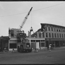
Lafayette Block demolition, Haverhill, ca. 1980 - Negative, Roll Film
Lafayette Block demolition, Essex Street, Haverhill. The buildings on the left side of the street, a three story block, are being demolished. Other multistory brick buildings on the left. A demolition crew worker in a hard hat is standing nearby. Post Office and Washington Square in the background. Multiple images. Photos from the Haverhill Gazette, circa 1980.
Record Type: Photo
-
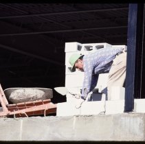
Man working on masonry, unidentified building, 1978 - Transparency, Slide
Man working on masonry, unidentified building. The man has grey hair and is wearing a baseball hat, shirt and pants. He is cementing concrete blocks with a trowel. Brick wall on the left. The man and location are not identified, probably in Haverhill. Date on slide: Oct 78, number 4.
Record Type: Photo
-
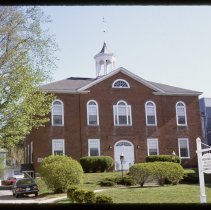
Merrimack Valley Planning Commission, Whittier Building, Haverhill, 1977 - Transparency, Slide
Merrimack Valley Planning Commission, Whittier Building, Winter Street, Haverhill. Whittier Building is two stories plus attic, fanlight in attic gable, door and second floor windows with fanlights, cupola. Sign in front of building "Merrimack Valley Planning Commission." Other buildings on the left and in the background. Parked cars. Inscription on housing: "Nick S. City Planner 1976-1983." Date on slide: May 1977, number 19.
Record Type: Photo
-
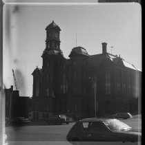
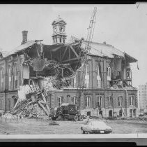
Old City Hall, Main Street, before and during demolition, Haverhill, 1973 - Negative, Roll Film
Old City Hall, Main Street, before and during demolition, Haverhill. Three stories plus basement, brick, four and five story towers in center including belfry and clock. View of front and right sides, front, tower with clock. The first six photos are before demolition, the seventh is the beginning of demolition on the left side. Cars, pedestrians. Building was demolished in 1973, photos probably taken within a few days. Call number is HH12.3.3 Se...
Record Type: Photo