Search Term Record
Metadata
Search Term |
Amesbury Road |
Number of Object records |
0 |
Number of Photo records |
35 |
Number of Archive records |
0 |
Number of Library records |
0 |
Related Records
-
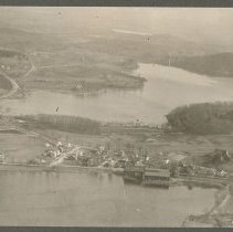
Aerial view of Haverhill, Round Pond / Lake Pentucket, Kenoza Lake, 1929 - Print, Photographic
Aerial view of Haverhill, Round Pond (Lake Pentucket) and Kenoza Lake, 1929. Round Pond is in the foreground, with Kenoza Lake in the background. Kenoza Avenue forks into Newton Road (far left) and Amesbury Road (right) which in turn forks to Kenoza Street (right). The Round Pond icehouse is visible on the shore. Inscription on verso: "Airplane view of Bradford - 1929 / Bradford Academy," an error. Photo is 14 x 18 cm mounted on cardboard 26 x 36...
Record Type: Photo
-
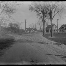
Amesbury Line Road, looking toward Amesbury Road, Haverhill, 1910 - Negative, Glass Plate
Amesbury Line Road, looking toward Amesbury Road, Haverhill. Road forks in the background. Houses on the left and in the distance. Photo taken May 5, 1910.
Record Type: Photo

-
Amesbury Road at Nicholsville, Haverhill, 1910 - Negative, Glass Plate
Amesbury Road at Nicholsville, Haverhill. Houses on both sides. Men working on the road on the right, horses and wagon in the bacground. Emulsion damaged. Label on glass: "88 F." Photo taken May 6, 1910.
Record Type: Photo
-
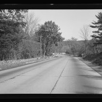
Amesbury Road, Haverhill - Negative, Roll Film
Amesbury Road, Haverhill. Low stone wall on left, fence on left and right. Trees on both sides. Water in the distance. Inscription on negative: "At Whittier's." Image early 20th century.
Record Type: Photo
-
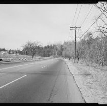
Amesbury Road, Haverhill - Negative, Sheet Film
Amesbury Road, Haverhill. Four lane road, two lanes in each direction. Sign for intersection with Route 108 in background. Lake on left, trees on right, houses in background.
Record Type: Photo
-
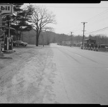
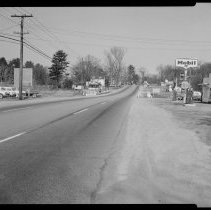
Amesbury Road, Haverhill, 1959 - Negative, Sheet Film
Amesbury Road, Haverhill, 1959. Mobil gas station on the left, wood building with storefront and "Authentic Antique Reproductions" painted on the side. Inscription on housing: "Watson 4/1/59."
Record Type: Photo
-
Amesbury Road, Haverhill, 1959 - Negative, Sheet Film
Amesbury Road, Haverhill, 1959. Cars and houses on the left, Mobil gas station on the right. Inscription on housing: "Watson 4/1/59."
Record Type: Photo
-
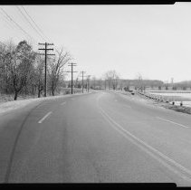
Amesbury Road/John Greenleaf Whittier Highway, Haverhill - Negative, Sheet Film
Amesbury Road, or John Greenleaf Whittier Highway (partially legible sign in distance), also known as Route 110. Four lanes, two directions; Kenoza Lake on right, trees on left.
Record Type: Photo
-
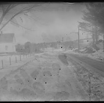
Amesbury Road, looking east toward Job's Hill, Haverhill - Negative, Glass Plate
Amesbury Road, looking east toward Job's Hill, Haverhill. Houses on both sides. Snow on the ground. Trolley tracks in the street. Emulsion damaged. Label on emulsion: "Smith #1 Amesbury Rd." Image probably early 20th century.
Record Type: Photo
-
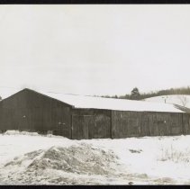
Barn, Amesbury Road, Haverhill, 1977 - Print, Photographic
Barn, across from 984 Amesbury Road, Haverhill. Large wood barn with gable roof, one story, house behind it on the left. Snow on the ground. Housing marked "Commercial" and dated November 25, 1977. The farm or business is not identified. From the CETA Project / A Photographic Record of All Structures in Haverhill, MA 1977-1978.
Record Type: Photo
-
Brandy Brow Road at the bottom of Saunders Hill, Haverhill, 1910 - Negative, Glass Plate
Brandy Brow Road, Haverhill. Intersection with another unidentified road. Houses, horses and carriage on the right. Another note on the housing reads "Bottom of Saunders Hill, probably Amesbury Road." Photo taken May 5, 1910.
Record Type: Photo
-
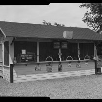
Butrick's Ice Cream stand, Amesbury Road, Haverhill - Negative, Sheet Film
Butrick's Ice Cream stand, Amesbury Road, Haverhill. Small stand with gable roof, sign on left: "Specials Today Milk Shakes 10¢." Separate signs with flavor lists for ice cream and frappes. Trees and fence in the background. Photo by Watson, probably circa 1930s.
Record Type: Photo
-
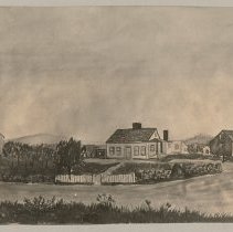
Daniel Cate Hoyt Homestead, Amesbury Road, Haverhill, drawing by Fred L. Noyes - Print, Photographic
Daniel Cate Hoyt Homestead, Amesbury Road, Haverhill, photograph of a drawing by Fred L. Noyes. Two story clapboard house with gable roof at center, fence in front with open gate, view of front and right sides. House has a portico on the right and a small shed extension. Barns on the left and right. Grass across the road in the foreground. Typed label: "Old Dan'l Cate Hoyt Homestead / [crossed out: East Broadway, replaced in ink with] Amesbury Rd...
Record Type: Photo
-
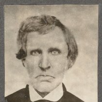
Daniel Cate Hoyt, Lydia William Hoyt, Hoyt's homestead, Hoyt Family Reunion 1901 - Print, Photographic
Daniel Cate Hoyt; Lydia William Hoyt; Daniel Cate Hoyt's homestead, and a group portrait from the Hoyt Family Reunion in 1901. The four photos are mounted together on cardboard 36 x 26 cm. Black and white copy negatives of originals. 1. Deacon Daniel Cate Hoyt. He has light or grey hair and light eyes. He is wearing a dark suit, white shirt and dark cravat or bow tie. Studio portrait. Original image mid or late 19th century. 10 x 7 cm. Inscripti...
Record Type: Photo
-
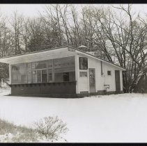
Hamburger stand, Amesbury Road, Haverhill, 1977 - Print, Photographic
Hamburger stand, Amesbury Road, Haverhill. Small clapboard or siding takeout-window structure with glass window and shelf at front, shed roof; no signs. View of front and right sides. Trees in the background, snow on the ground. Housing has date, street and name "Hamburger stand." Housing dated November 28, 1977. From the CETA Project / A Photographic Record of All Structures in Haverhill, MA 1977-1978.
Record Type: Photo
-
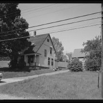
House, Amesbury Road, Haverhill - Negative, Sheet Film
House, 330 Amesbury Road, Haverhill. Front and right sides, small building in background on the right. Three stories, clapboard, with porch in front. Inscription with print in file: "330 Amesbury Road / House has been moved to Elliott St cr. Shattuck Rd. / Owned by Mary Daggett 1959 / Site is now occupied by Seafood Etc owned by Michael Daggett. Watson 5/29/62."
Record Type: Photo
-
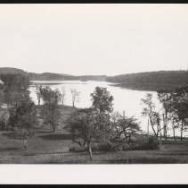
Kenoza Lake - Print, Photographic
Kenoza Lake, with the Haverhill Water Treatment building at left and Amesbury Road along the lake. Electricity lines are also visible along the road. Orchard in foreground. Copy photo of earlier original. Undated.
Record Type: Photo
-
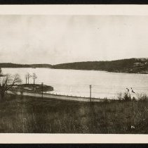
Kenoza Lake, 1936 - Print, Photographic
Kenoza lake in 1936. Amesbury Road is visible infront of the lake, and the Haverhill Water Division buildings at the far left. 1936.
Record Type: Photo
-
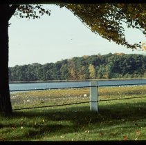
Kenoza Lake at Amesbury Road, Haverhill, 1975 - Transparency, Slide
Kenoza Lake at Amesbury Road, Haverhill. Wire cable fence in the foreground. Inkstamp of John O. Toivola on slide mount. Date on slide: Oct 75, number 1.
Record Type: Photo
-
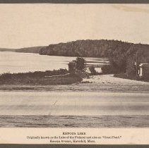
Kenoza Lake, Haverhill - Print, Photomechanical
Kenoza Lake, Haverhill. View from across Amesbury Road, pillars on either side of Dudley Porter Road leading around the lake. Far shore with trees in the distance. Photomechanical print of a photograph from an unidentified publication, printed in reddish purple ink. Printed caption: "Kenoza Lake / Originally known as the Lake of the Pickerel and also as 'Great Pond.' / Kenoza Avenue, Haverhill, Mass." Print is 13 x 17 cm mounted on cardboard 26 x...
Record Type: Photo