Search Term Record
Metadata
Search Term |
Aerial views |
Number of Object records |
0 |
Number of Photo records |
122 |
Number of Archive records |
0 |
Number of Library records |
0 |
Related Records
-
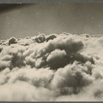
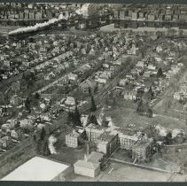
Aerial view, clouds over Haverhill, 1929 - Print, Photographic
Aerial view, clouds over Haverhill, 1929. Three photos, the largest approximately 9 x 11 cm, mounted together on cardboard 26 x 36 cm. Part of the airplane is in the upper left in the first two photos. Inscription on verso: "Airplane view over Haverhill - 1929 / 8200 ft. altitude."
Record Type: Photo
-
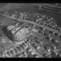
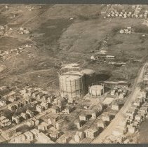
Aerial view, gas storage tanks, Haverhill, 1929 - Negative, Glass Plate
Aerial view, gas storage tanks, Haverhill. Houses, Hilldale Avenue; Little River visible. See also HG9 Senter HPH 26-355E, HH15.2 Senter HPH 26-356A, Senter HPH 26-356B, dated 1929.
Record Type: Photo
-
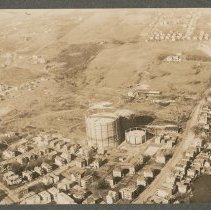
Aerial view, gas storage tanks, Haverhill, 1929 - Print, Photographic
Aerial view, gas storage tanks, Haverhill, 1929. Houses, Hilldale Avenue; Little River visible. Inscription on verso: "Airplane view of Haverhill - 1929 / Little River, Hilldale Ave. - Gas Co's Reservoir." See also HH15.2 Senter G4x5 7-18, HG9 Senter HPH 26-355E, Senter HPH 26-356B. Photo is 13 x 18 cm mounted on cardboard 26 x 36 cm.
Record Type: Photo
-
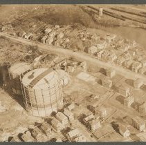
Aerial view, gas storage tanks, Haverhill, 1929 - Print, Photographic
Aerial views, gas storage tanks, Haverhill, 1929. Houses, Hilldale Avenue; Little River visible. Inscription on verso: "Airplane view of Haverhill - 1929 / Hilldale Ave. with Gas Co's Reservoirs." See also HH15.2 Senter G4x5 7-18, HG9 Senter HPH 26-355E, Senter HPH 26-356A. Photo is 13 x 18 cm mounted on cardboard 26 x 36 cm.
Record Type: Photo
-
Aerial view, gas storage tanks, Haverhill, 1929 - Print, Photographic
Aerial views, gas storage tanks, Haverhill, 1929. Houses, Hilldale Avenue; Little River visible. Inscription on verso: "Airplane view of Haverhill - 1929 / Little River, Hilldale Ave. & Broadway." Four photos from different directions, approximately 8 x 11 cm mounted on cardboard 26 x 36 cm. Images probably early 20th century. See also HH15.2 Senter G4x5 7-18, HH15.2 Senter HPH 26-356A, Senter HPH 26-356B.
Record Type: Photo
-
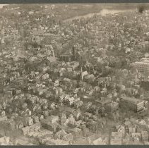
Aerial view, Main Street and Monument Square, Haverhill, 1929 - Print, Photographic
Aerial view, Main Street and Monument Square, Haverhill, 1929. The rear of North Congregational Church and the left side of the First Universalist Church are visible with Monument Square to the left, and Haverhill High School is on the right at the corner of Summer Street. Lake Saltonstall is near the top of the frame. Inscription on verso: Airplane view of Haverhill - 1929 / North Church (center) - High School (right)." Photo is 14 x 19 cm mount...
Record Type: Photo
-
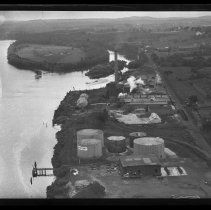
Aerial view of Box Board Company, Oil Tanks, and Hales Island, Bradford, 1929 - Negative, Glass Plate
Aerial view of Haverhill Box Board Company, Standard Oil Tanks, and Hales Island, looking East, Bradford, Haverhill, 1929. Merrimack River on the left, railroad tracks on the right.
Record Type: Photo
-
Aerial view of Box Board factory, Elmwood Cemetery, Bradford, Haverhill, 1929 - Print, Photographic
Aerial view of Haverhill Box Board Company factory, Elmwood Cemetery, Bradford, Haverhill, 1929. The cemetery is on the left, the factory on the right. Haverhill (north) at top right, across the Merrimack River, Haverhill Bridge. Inscription on verso: "Airplane View of Haverhill - 1929 / Boxboard Factory (right) - Cemetery (left)." Photo is 14 x 19 cm mounted on cardboard 26 x 36 cm.
Record Type: Photo
-
-
-
-
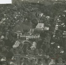
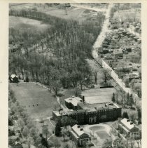
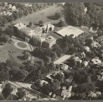
Aerial view of Bradford Academy, Bradford, Haverhill, 1929 - Print, Photographic
Aerial view of Bradford Academy, Bradford, Haverhill, 1929. Academy Hall is the main building, brick, multistory. Haverhill (north) is at the top of the image across the Merrimack River. The County Bridge and Railroad Bridge with train heading south are on the left. Inscription on verso: "Airplane view of Bradford - 1929 / Bradford Academy." See HG9 Senter HPH 28-389D. Photo is 13 x 18 cm mounted on cardboard 26 x 36 cm.
Record Type: Photo
-
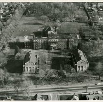
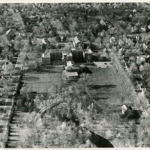
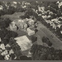
Aerial view of Bradford Academy, Bradford, Haverhill, 1935 - Print, Photographic
Aerial view of Bradford Academy, Bradford, Haverhill, 1935. Academy Hall is the main building, brick, multistory. Inscription on verso: "Photo by Arthur H. Moran / Airplane view of Bradford - 1935 / Bradford Academy." See also HG9 Senter HPH 28-384E. Photo is 16 x 21 cm mounted on cardboard 26 x 36 cm.
Record Type: Photo
-
Aerial view of Bradford Academy, Bradford, Haverhill, 1935 - Print, Photographic
Aerial view of Bradford Academy, Bradford, Haverhill, 1935. Academy Hall is the main building, brick, multistory. Inscription on verso: "Photo by Arthur H. Moran / Airplane view of Bradford - 1935 / Bradford Academy." See also HG9 Senter HPH 28-382A. Photo is 16 x 21 cm mounted on cardboard 26 x 36 cm.
Record Type: Photo
-
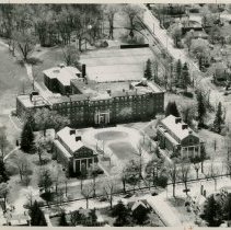
Aerial view of Bradford Academy Library, 1957 - Print, Photographic
Transcribed from item: Library, 12075, Page 44, pos 1
Record Type: Photo
-
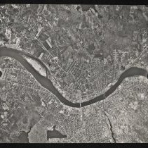
Aerial view of Bradford and Haverhill, 1971 - Print, Photographic
Aerial view of Bradford and Haverhill. The right side shows what looks like airplane instrument dials; the dial at bottom right reads "UAg 272 / 1241 / 52,56." In this view Bradford is at the top (south) and Haverhill is at the bottom (north). Hales Island is on the left. The Haverhill Bridge is in the center and the County Bridge and Railroad Bridge are on the right. Date on verso of insert: "15 May 1971." Second image is corrected.
Record Type: Photo
-
Aerial view of Bradford, Haverhill - Negative, Glass Plate
Aerial view of Bradford, central area, South Main Street; Haverhill Bridge and downtown Haverhill at top of image. Possibly 1929.
Record Type: Photo

-
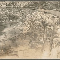
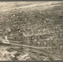
Aerial view of Bradford, Haverhill, 1929 - Print, Photographic
Aerial view of Bradford, Haverhill, 1929. Bradford Depot / Bradford Station and railroad tracks at the bottom of the image, with train on the left. The steeple of the First Church of Christ, also known as the White Church, is visible near the upper right. The Merrimack River and Haverhill (north) are at the top of the image. Photo is 14 x 19 cm mounted on cardboard 26 x 36 cm.
Record Type: Photo
-
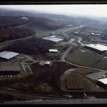
Aerial view of Bradford, Haverhill, 1977 - Transparency, Slide
Aerial view, Ward Hill, Bradford, Haverhill. Several large commercial buildings, highway and access roads, water tank on the left on the hill. Inscription on slide mount: "WHIP WEST / EC DEV." Date on slide: Nov 77, number 27.
Record Type: Photo
-