Creator Record
Metadata
Name |
Tarr, Lewis L. |
Related Records
-
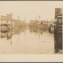
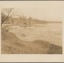
Bradley Avenue at Riverside Tavern looking east, 1936 - Print, Photographic
Flood of 1936, looking east near Riverside Tavern along River Street/MA-113. Merrimack River is nearly up to the tracks on the right of the image. Several houses and cars are in the distance, and a few people are on the street. Photographer Lewis L. Tarr, March 23, 1936.
Record Type: Photo
-
Bradley Avenue at Riverside Tavern looking west, 1936 - Print, Photographic
Bradley Avenue at Riverside Tavern, looking west after the Flood of 1936. Workers and cars are repairing the building to the right of the photo. Photographer Lewis L. Tarr, March 22, 1936.
Record Type: Photo
-
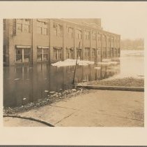
Bradley Avenue showing Brandano buildings, 1936 - Print, Photographic
Bradley Avenue showing Brandano buildings on River Street, during the Flood of 1936. The buildings in the background are nearly completely submerged in the floodwater. A house is at the far left with water up to its foundation. Photographer Lewis L. Tarr, March 14, 1936.
Record Type: Photo
-
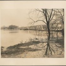
Bradley's Brook looking East, 1936 - Print, Photographic
Bradley's Brook looking east. Ice and snow float in the high water. Houses are in the distance along a road, with brookside houses partially submerged in water. Photographer Lewis L. Tarr, March 14, 1936.
Record Type: Photo
-
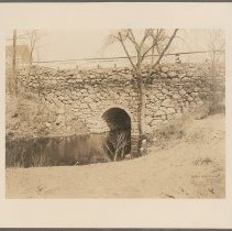
Cave-in of Bradley's Brook Bridge at Lowell Avenue, 1936 - Print, Photographic
Bradley's Brook Bridge at Lowell Avenue. A fence lines the bridge and a house is on the left side of the bridge. Photographer Lewis L. Tarr, March 30, 1936.
Record Type: Photo
-
Elliott Place looking south across the river, 1936 - Print, Photographic
View of Elliot Place looking south across the Merrimack River. Water has risen to the windows of the building. Some snow is floating in the water. "70" and "7376" on verso. Photographer Lewis L. Tarr, March 14, 1936.
Record Type: Photo
-
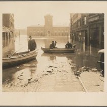
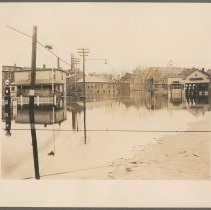
Emerson Street looking into Washington square, 1936 - Print, Photographic
Emerson Street looking into a flooded Washington Square. Four men--Carl Witham, Jakie [sic] Curtin, David Ring, and Irving (Erving H.) Malcolm--sit left to right in two rowboats near the edge of the flood water. The tire of a car is the right edge of the image, and debris floats in and at the edge of the water. Photographer Lewis L. Tarr, March 20, 1936.
Record Type: Photo
-
Emerson Street looking into Washington Square and Elliot Place, 1936 - Print, Photographic
Emerson Street looking into either Washington Square and Elliot Place. Businesses line the street, including H. E. Tuck & Son on the left, and water nearly covers the first floors of the buildings. A rowboat is in the background on the floodwater. Photographer Lewis L. Tarr, March 21, 1936.
Record Type: Photo
-
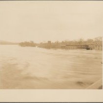
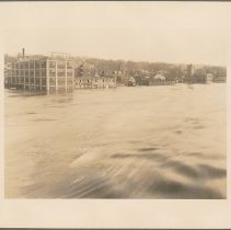
Ferry Street, Bradford, looking across Merrimack River, 1936 - Print, Photographic
Ferry Street in Bradford looking across the Merrimack River. Several buildings are nearly completely underwater. Haverhill on the opposite bank. Photographer Lewis L. Tarr, March 20, 1936.
Record Type: Photo
-
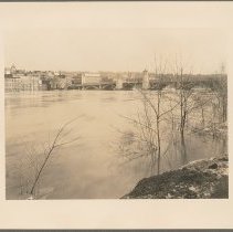
From Center Haverhill Bridge looking toward south shore, 1936 - Print, Photographic
The Merrimack River from the center of the Haverhill Bridge (Basiliere Bridge) looking toward the south riverbank. Water nearly submerges the Taylor-Goodwin Coal & Lumber buildings. Photographer Lewis L. Tarr, March 20, 1936.
Record Type: Photo
-
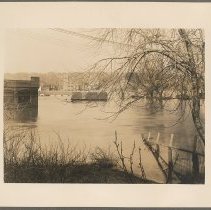
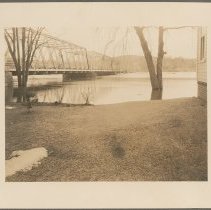
Groveland Bridge, 1936 - Print, Photographic
Groveland Bridge during a flood. Water has risen to reach the bridge deck, and debris caught against the bridge supports. "6246" on verso. Photographer Lewis L. Tarr, March 21, 1936.
Record Type: Photo
-
Groveland Bridge showing condition after flood receded, 1936 - Print, Photographic
The Groveland Bridge over Merrmimack River, showing conditions after the Flood of 1936 receded. Water is still up to the bridge deck, and debris is piled against the bridge from the water. Photographer Lewis L. Tarr, March 23, 1936.
Record Type: Photo
-
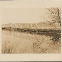
Groveland Bridge, west side from Riverside Avenue, 1936 - Print, Photographic
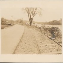
The west side of the Groveland Bridge as seen from Riverside Avenue, Haverhill. Merrimack River water is nearly to the top of the pilons; verso states the the river elevation is 20.5 feet in this image. The corner of a house is at the right side of the photo. Photographer Lewis L. Tarr, March 14, 1936.
Record Type: Photo
-
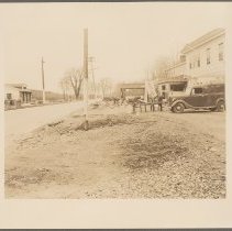
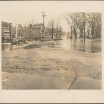
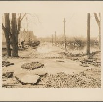
Groveland Street, junction Lincoln Avenue, 1936 - Print, Photographic
The junction of Groveland Street and Lincoln Avenue. Water, mud, and silt have collected in the road from the flood of 1936. Cars are parked at a building with the signs "DeSoto Six" and "Texaco Gasoline, Motor Oil." Several people are walking down the street. "5164" on verso. Photographer Lewis L. Tarr, March 14, 1936.
Record Type: Photo
-
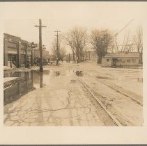
Groveland Street junction Lincoln Avenue after flood, 1936 - Print, Photographic
Groveland Street at Lincoln Avenue after the Flood of 1936. Large puddles of water, mud, and silt cover the road. A house is to the right and DeSoto Six Texaco gas station is on the left. The street continues onto the Groveland Bridge in the background. Photographer Lewis L. Tarr, March 23, 1936.
Record Type: Photo
-
Groveland Street looking into Riverside Avenue after flood, 1936 - Print, Photographic
Groveland Street looking towards Riverside Avenue after teh Flood of 1936. Mud, silt, and debris are on the road. Receding water is in the background. "6154," and "29" on verso. Photographer Lewis L. Tarr, March 23, 1936.
Record Type: Photo
-
Haverhill Bridge looking toward Water Street, 1936 - Print, Photographic
Haverhill Bridge looking toward Water Street during the Flood of 1936. Merrimack River has risen to midway up the first floor of the buildings in the background. "74" and "6279" on verso. Photographer Lewis L. Tarr, March 14, 1936.
Record Type: Photo
-
Haverhill Bridge west side from Bradford-20.5 Elev, 1936 - Print, Photographic
Haverhill Bridge (Basiliere Bridge) from Bradford. Water has risen to the bottom of the bridge arches and Haverhill can be seen across the Merrimack River. "20.5 Elev." note on verso suggests that the river level is 20.5 feet higher than normal. Photographer Lewis L. Tarr, March 14, 1936.
Record Type: Photo
-
Lafayette Square looking into Winter Street, 1936 - Print, Photographic
Lafayette Square looking into Winter Street during the flood of 1936. The edge of the water can be seen in the lower right hand corner. Several houses and businesses, including a Socony gas station and Quintal & LeBlanc garage, line the street. "6600" on verso. Photographer Lewis L. Tarr, March 21, 1936.
Record Type: Photo
-
Lafayette Square looking onto Winter Street, 1936 - Print, Photographic
Lafayette Square looking onto Winter Street during the Flood of 1936. Water fills the square and street. A person stands on the corner to the right in front of Comeau's Cafe, Willard Garage behind the building. A boat passes through the square on the left. Photographer Lewis L. Tarr, March 20, 1936.
Record Type: Photo